3D Mapping Cameras: What Are They and How Do They Work?

Have you ever been to a museum or seen a piece of street art that you wish you could document and look at later? While you can take photos of such a piece, a photo doesn’t quite do justice to all the different angles and details of an object in the real world.
This will no longer be a problem if you have a 3D mapping camera. With this, you can generate a 3D model of any solid object, room, or even an outdoor space. How does this technology work and how easily can it be accessed?
How do 3D mapping cameras work?
The problem with normal photos is that they reduce any three-dimensional space into a flat image. This loss of depth, something we’ve gotten used to, makes it difficult to capture the “feel” of an object or space with traditional photography.
What makes images different from what we see with our eyes? The answer is that cameras only have a single image sensor. This is in contrast with the fact that we have two eyes, capturing two simultaneous images of everything we look at and combining the images in our brains. This conveys to our brains a sense of depth. If you’ve ever tried walking down a flight of stairs with one eye closed, then you probably know how it feels to lose your sense of depth.
3D mapping companies use the same concept to incorporate depth into the photos that they take. This is either done through stereoscopy or photogrammetry.
Stereoscopy refers to the technique of creating depth in an image by using binocular vision. This had been used since the 1980s to create stereograms – a pair of slightly overlapping images that you can view using a stereoscope. However, the illusion of depth that old-fashioned stereoscopy can create is very limited and does not create a “true” 3D model.
By extending the concept to images captured in real-time using a moving camera, the stereoscopy technique can be used for 3D mapping. This is done using a stereo camera, or a camera with two image sensors located side-by-side, separated only by a few inches. A stereo camera captures thousands of stereograms, eventually combining the illusion of depth to create a fully realized 3D model.
Stereoscopy is a technically simple method because it uses concepts that have been practiced for decades. The problem is that not everyone has a stereo camera. You’ll need to buy one, and it’s really not good for anything else aside from 3D mapping and modeling.
The second technique, called photogrammetry, is a step towards democratizing technology. It uses the same concept – that of combining overlapping images to create depth – but requires just a single camera. Photogrammetry is highly dependent on software which determines how much and where the images should be captured.
The best thing about photogrammetry is that you don’t need special cameras for 3D mapping. There are now photogrammetry software platforms that are designed to work with images captured by DSLR cameras. There are even apps that can be installed on mobile devices, allowing you to craft 3D maps using just an iPad.
In both stereoscopy and photogrammetry, the most resource-intensive step of the process is the generation of the 3D model or map using the series of overlapping images. This step is also typically aided by some sort of AI, effectively generating a point cloud with each point integrated with spatial data. The result is a faithful reproduction of 3D space that is fully navigable and measurable.
A few examples of 3D mapping cameras
Zed 2 from Stereolabs
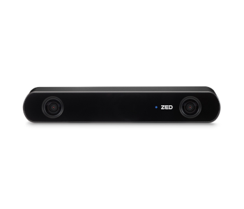
If you’re looking for stereo cameras, then the most popular model right now is the Zed 2 from Stereolabs. This is a dual-sensor stereo camera with 2K resolution and cutting-edge software. The camera uses neural networks to simulate how the human brain processes the images captured by the eyes, giving it a whole new level of stereo perception.
To enhance positional tracking and spatial intelligence, the Zed 2 comes with a complete suite of sensors including an accelerometer, barometer, IMU, and magnetometer. The cloud-based platform is useful not just for processing images for 3D modeling, but also for remote monitoring of live video streams and data collection.
The strength of the Zed 2 lies in its neural network-powered spatial awareness. By incorporating this AI with third-party development environments such as Python or Unity, the Zed 2 can be integrated with applications such as obstacle detection and avoidance, real-time-mapping, and tracking of human movement. We probably haven’t seen all the possibilities that this technology has to offer.
Matterport 3D Data Solutions
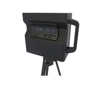
If you’re not eager to buy a stereo camera just for 3D mapping, then a photogrammetry software platform that’s compatible with your mobile device sounds like the better option. One such platform is Matterport. Although Matterport sells their own Pro2 camera, their software platform is also compatible with 360 cameras from other brands, such as the Ricoh Theta V or the Insta360 One X. If you want even better resolution, you can use the LiDAR-based Leica Blk360 camera.
The best offering from Matterport is the Matterport Capture app, a 3D capture app that is compatible with iOS devices. This makes the process of capturing images for 3D modeling incredibly simple because the app will prompt you to move the camera as needed. After the needed images have been captured, they are all uploaded to the Matterport Cloud where processing and model generation happens.
After the model has been generated, you can play around with it in Matterport Workshop. You can trim the edges of the model, add tags, label the rooms, make measurements, and create a highlight reel for the model. When it’s time to show it off, just fire up the Matterport Showcase app. This is great for showing off the 3D map and sharing the model in the usual social media channels.
The model as displayed in Matterport Showcase is also compatible with most 3D headsets. If you have an Oculus or Google Cardboard headset, simply download the Matterport VR app or launch the model straight from Matterport Showcase.
3D mapping using drones
So far, we’ve only talked about generating 3D maps from the ground. With the solutions provided by the likes of Matterport and Stereolabs, we can create 3D maps of our living rooms, the nearby local park, an interesting piece of street art, or our favorite museum exhibits. But is it possible to take things a step further and use the same technology to create 3D models of skyscrapers and several hectares’ worth of terrain?
Yes, it’s possible and is something that drones have been able to do for years. Drone-mounted cameras are perfect for photogrammetry on account of how excellent they are. High-end drones released in the last couple of years can typically record in 4K resolution and are mounted on mechanical gimbals that help keep them stable, even when flying in windy conditions.
The beauty of combining drones with 3D mapping technology is that it allows for the use of drones for 3D modeling at a scale that cannot be achieved by a handheld camera. Drones can fly around houses and skyscrapers. They can even fly across vast tracts of land, tracing a flight path that has been specially designed to capture overlapping images.
To accomplish 3D mapping with drones, special photogrammetry software is needed. Software platforms like Pix4D are specifically designed to be used with drones. Not only do they generate models at a larger scale and with more output options, but they also have modules for flight mission planning.
Through the companion mobile app, the drone pilot can simply define the boundaries of the planned survey area and the app can automatically generate a flight path. The flight path then gets uploaded to the drone to let it fly automatically. This makes the whole process very convenient, accurate, and repeatable.
Just as with ground-based mapping techniques, the images captured in a survey are typically uploaded to a cloud-based server for processing. The model can then be downloaded in several different formats, including standard ones used by popular platforms like AutoCAD or ArcGIS.
What are 3D mapping cameras used for?
Whether ground-based or drone-aided, 3D mapping is proving to be one of the most revolutionary technologies in the past couple of years. A good 3D map is invaluable in the planning and execution of projects across several industries. It’s also a very good marketing tool is many people still see it as something novel and unfamiliar.
Here are just some of the more interesting applications of 3D mapping:
Real estate marketing
3D maps have been recognized as very effective marketing tools for real estate agents. This is an industry that can benefit from both ground-based and drone-aided 3D mapping. Models created from 360 cameras are perfect for showing off the interior of a house, allowing potential buyers to walk through the property without having to make a physical visit. This is a level of immersion that is simply not possible with just plain images.
Taking it a step further, real estate agents can also create 3D models of the exterior of a house. By showing off the house and its surroundings, buyers can get a better sense of scale and can even see how the roof of the house looks like. A drone flying around the house can capture all the needed images to create the model in just a few minutes.
Urban planning
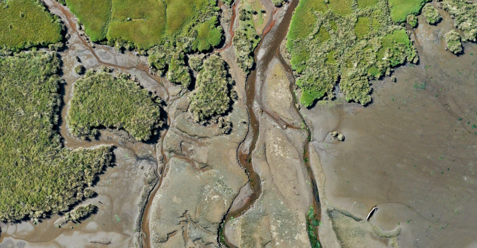
When a city plans for roads and buildings, accurate terrain data is invaluable. In the past, ground-based survey crews had to spend several weeks capturing elevation data from several points to create a topography model. However, a drone armed with a good camera can accomplish the same job in just a few hours.
An accurate topography map allows urban planners to plan optimal routes for roads and locations for buildings. If there are steep slopes, they can also enact safety measures to stabilize them or avoid them altogether. Resource allocation is made easier because they can exactly how long the roads need to be and the amount of excavation work that needs to be done. Even watersheds can be easier to identify with a topographic map.
Tourism and travel
With all the novelty and WOW factor of 3D models, it’s unsurprising how effective it is as a marketing tool for resorts, theme parks, beaches, hotels, and other recreation spots. With a 3D map, interested guests can do a visual walkthrough of the facilities, making them more confident when they make a booking. It’s also a very convenient marketing tool as it can be shared in most social media channels.
3D maps have been proven to increase occupancy rates in many hotels and resorts worldwide by more than 10%. Web engagement numbers have also been seen to increase by up to 15%.
Insurance claims
When making an insurance claim in your property, you’ll have to document any damage for which you are making the claim. This can be a frustrating experience, more so if it’s for massive damage caused by a natural disaster. In this situation, a 3D map is the best way to make sure that you don’t miss any of the details.
If you’re an insurance adjuster on the other end of the conversation, then you can also use 3D maps to make your own loss and damage documentation. You can even use a drone to document any damage on the roof, capturing a great amount of detail without exposing yourself to fall hazards. A 3D map is an invaluable tool for insurance adjustment as it lets you review and document small details in the comfort of your office.
Construction and civil engineering
3D mapping can be valuable in practically all stages of a construction project. In the planning phase, you can fly a drone to create a topography model of the project site, providing information on how much excavation will be needed or if any of the terrain needs to be modified for delivery of supplies and equipment.
During the construction phase, 3D maps and models can be regularly generated as a means to record the progress of the project. Either ground-based or aerial models can be useful in this regard, as you may want to show both the interior and exterior of the project being constructed.
Finally, what better way is there to document a finished construction project than with a full 3D model? If the property will be sold, then a 3D map will be a great way to draw in potential buyers. For a commercial establishment, a virtual walkthrough will be an excellent way to pique the interest of visitors.
Final thoughts
3D maps certainly are enthralling pieces of work. The great news is that you don’t need any fancy equipment to make your own 3D map, as some apps make it possible to use just the camera of your phone. For those who own drones, the combination of 3D mapping technology and the mobility of drones open up even wider possibilities.
3D mapping seems like one of the next new frontiers of the democratization of advanced technology. With a wider user base, we can expect even more innovative and creative uses of 3D mapping in the next few years.
I’m interested in learning more about 3D mapping and how I can start doing it for myself