
Beginner’s Guide to the Different Airspace Classes

For the last couple of years, the FAA has started to treat drone pilots as “airmen” who are equally responsible for the safety of national airspace as any licensed pilot. For this responsibility to be put into practice, one of the most crucial topics that drone pilots need to learn about is airspace classes.
As you can expect, drone pilots can’t just fly their drones wherever and whenever they like. Depending on your location, you may need to ask for approval before you can fly your drone or be outright restricted from doing so. In this article, we go through the different airspace classes, the related restriction per class, and how to identify them in a sectional chart.
Controlled airspace vs. special use airspace vs. uncontrolled airspace
The broadest distinction that one needs to know about the national airspace is the difference between controlled, uncontrolled, and special use airspace.
Controlled airspace refers to the airspace defined in 3-dimensional space where air traffic control (ATC) services are provided. This does not mean that ATC will always be available in controlled airspace, as the level of control may vary according to different airspace classes. Controlled airspace is typically found in the vicinity of airports, declared so because of the high volume of air traffic.
Flight under both visual flight rules (VFR) and instrument flight rules (IFR) is permitted in controlled airspace. There are six classes of controlled airspace, from Class A to Class E, arranged in decreasing order of the degree of ATC regulation.
Uncontrolled airspace is airspace where no ATC regulation service is provided or required, mostly due to practical reasons. These are typically areas with low air traffic volume. Most aircraft flying in uncontrolled airspace fly under VFR, with those flying under IFR not expecting reciprocity.
Uncontrolled airspace is often referred to as Class G airspace. Although there is a lot of material that may refer to uncontrolled airspace as Class F, the standards of the International Civil Aviation Organization (ICAO) has declared that there is no such thing as Class F airspace.
Special use airspace can be designated to an area according to a variety of reasons and correspondingly also have a different level of air traffic restrictions. Often, the reasons for declaring an area of airspace as special use is related to some military activity. Areas with temporary flight restrictions (TFR) are also considered special use airspace and are usually declared for events that draw huge crowds over which aircraft flight is deemed too dangerous.
Controlled Airspace
For most types of controlled airspace, drone pilots need to ask for ATC authorization before they are legally allowed to fly their drones. This means that drone pilots need to know if their planned drone flight mission falls within the boundary of controlled airspace. This knowledge includes not just the horizontal extent of the controlled airspace, but also the altitude of its base and ceiling.
Class A (Alpha) Airspace
Sectional Chart Representation: Not shown
Class A airspace starts from 18,000 feet up to 60,000 feet – way beyond the flight capabilities of most drones. This airspace is mostly used by commercial airlines for traveling between cities or countries. They are not represented in sectional charts and are not relevant to drone pilots.
Class B (Bravo) Airspace
Sectional Chart Representation: Solid blue line
Class B airspace refers to the airspace surrounding the country’s busiest airports, including major air travel hubs in New York, Chicago, and Los Angeles. The extent of Class B airspace typically reaches up to 10 nautical miles from the airport and can have two or more layers arranged in an “upside-down cake” manner, where the wider layers are placed at the top. ATC approval will be needed for drone flight in Class B airspace.
To illustrate how the geometry of Class B airspace can vary at different points and elevations, let’s look at the sectional chart representation of the Class B airspace surrounding the Phoenix Sky Harbor International Airport (KPHX):
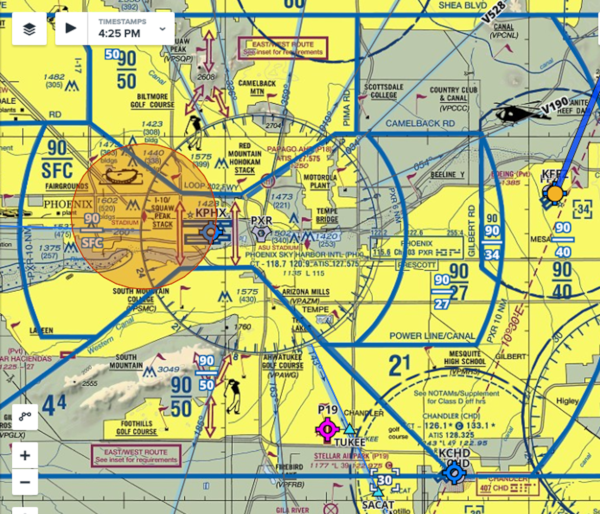
As you can observe, there are several solid blue lines demarcating different regions on the map. Another thing you’ll notice is that airspace layers don’t necessarily have to take the shape of a circle, although they usually do.
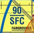
The innermost region of this Class B airspace is labeled by this symbol. Simply put, the symbol defines the altitude and ceiling of the base of the controlled airspace. In this case, the controlled airspace in the immediate vicinity of the runway starts at the surface and extends up to 9000 feet.
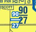
As we move further away from the airport runway, the vertical extent of the controlled airspace decreases because of a higher base altitude. To the immediate east of the runway, the base of the Class B airspace starts at 2700 feet and extends up to 9000 feet.
There are several other similar symbols scattered around the map. The area to the north and south of the runway has Class B airspace starting at 5000 feet, while the area to the far east surrounding the Falcon Field Airport (KFFZ) has a Class B airspace starting at 4000 feet.
For the drone pilot, the base of the controlled airspace plays huge role in determining whether or not they need to secure ATC authorization before flying. In this case, the base of Class B airspace surrounding KPHX is well above the 400-foot altitude limit of drones, unless you’re flying your drone very close to the runway.
Class C (Charlie) Airspace
Sectional Chart Representation: Solid magenta line
Class C airspace is very similar to Class B expect it applies to smaller and less busy airports. The extent of Class C airspace can reach up to 10 nautical miles horizontally and have a maximum altitude of around 4000 feet. Much like Class B, the geometry of Class C airspace also resembled an upside-down cake with a wider layer at the top of a smaller layer. ATC approval will be needed for drone flight in Class C airspace.
An example of Class C airspace is the area surrounding the Nashville International Airport, as represented by this fragment of a sectional chart:
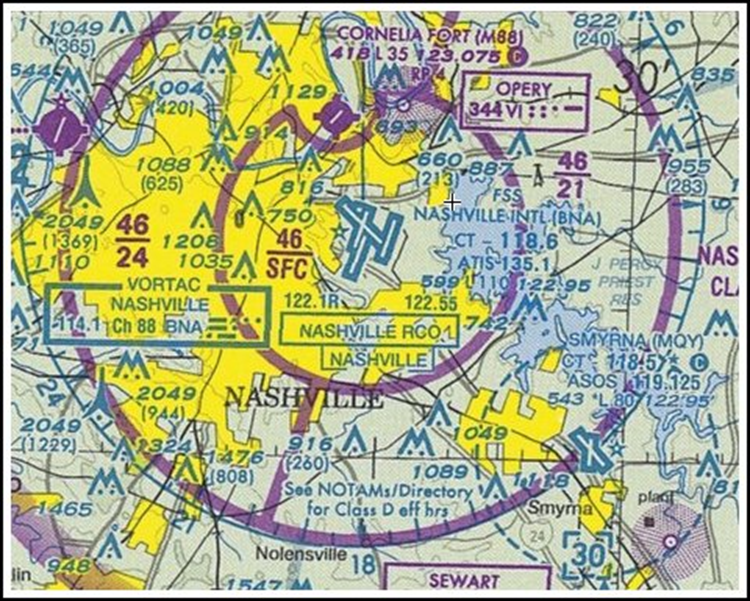
Again, the same symbols representing the altitude of the base and ceiling of the controlled airspace are indicated in the sectional chart. In this case, the Class C airspace in the immediate vicinity of the airport runway start at the surface and extend up to an altitude 4600 feet.
The half-circle outer layer of this particular Class C airspace that is located on the east side has a base at 2100 feet, while the west side is a bit higher at 2400 feet. These slight variations in geometry are often the result of the interaction of the controlled airspace with other nearby infrastructure or may consider the direction of air traffic in this facility.
Class D (Delta) Airspace
Sectional Chart Representation: Blue dashed line
Class D airspace is much smaller than the two previous controlled airspace types – typically with a 5-mile diameter extent and a maximum altitude of 2500 feet. This type of controlled airspace is usually assigned to the smallest airports with functioning control towers. ATC approval will be needed for drone flight in Class D airspace.
Unlike the two previous controlled airspace types, Class D airspace always starts at the surface. This makes Class D airspace much easier to represent in sectional charts. Let’s look at the example of the Class D airspace surrounding the Pueblo Memorial Airport (PUB):
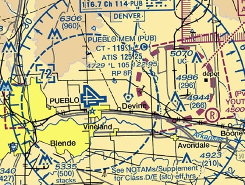
The Class D airspace only needs to be labeled with a single number – the ceiling of the airspace. In this case, the Class D airspace surrounding PUB extends up to 7200 feet. Off to the east of the scope of the Class D airspace, you may notice a much smaller circle bounded by magenta dashed lines. This is Class E airspace that has been designated as an extension of PUB’s Class D airspace, likely put in place to aid in aircraft approach to the runway.
Class E (Echo Airspace)
Sectional Chart Representation: Several (see below)
Class E airspace is assigned to all other areas of controlled airspace that are not covered by the previous types. Basically, Class E airspace “fills in” the empty spaces left by the unique and unusual geometries of Classes B, C, and D.
Class E airspace can be represented in sectional charts in a couple of different ways according to the base altitude where they start. For the most part, drone flight in Class E airspace can be done without ATC authorization, but there are still a few rare exceptions.
![]()
Class E airspace starting at the surface and extending up to 700 feet above the surface.

Class E airspace from 700 feet to 1200 feet above the surface.
![]()
Class E airspace with the floor starting at 1200 feet above the surface.

Indicates floors of Class E airspace greater than 700 feet above the surface.
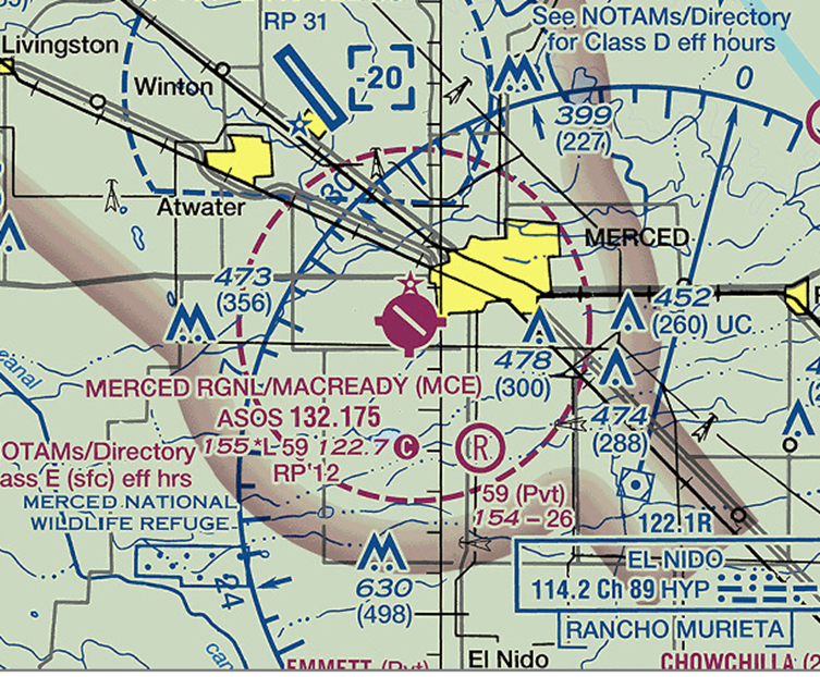
The general rule to follow when flying drones in Class E airspace is that you’ll still need ATC authorization if there’s an airport that falls within the scope of Class E airspace (like in the example for the Merced Regional Airport below). Otherwise, you’re good to go even without ATC authorization.
Uncontrolled airspace
Also referred to as Class G (Golf) airspace, this is the least restrictive of all airspace types. Anything that is not considered under Controlled or Special Use Airspace can be automatically be assumed to be Uncontrolled. Since there is no ATC in Uncontrolled Airspace, there is no need to secure any type of authorization to fly your drones. Uncontrolled Airspace is not explicitly labeled or marked in Sectional Charts.
Take note that although there is no need to secure any authorization when flying drones in Uncontrolled Airspace, you still need to follow general flight rules and restrictions. The most important of these is ensuring that you fly only up to a maximum altitude of 400 feet above the surface, always give way to manned aircraft, and to not fly your drone over crowds or any non-participating person.
Special Use Airspace
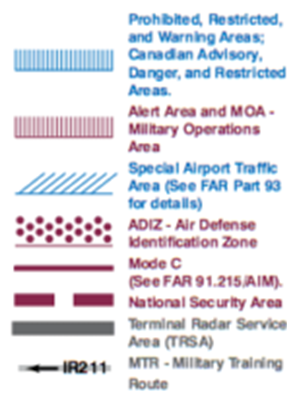
As we’ve mentioned, there are several different types of Special Use Airspace according to use and applicable restrictions. Most of the reasons for declaring Special Use Airspace are military in nature or have to do with national security, so you’d best heed any rules that restrict or prohibit drone flight in these areas. Thankfully, they are very easy to spot in sectional charts and have names that are intuitive and self-explanatory. A handy guide to the marks used to identify Special Use Airspace in sectional charts can be found below:
Prohibited Areas
As its name implies, all drone flight (and any flight, for that matter) is prohibited in Prohibited Areas even if you have secured prior ATC authorization. The reasons for declaring airspace as a Prohibited Area usually involve national security and welfare. Prohibited Areas are marked by solid blue lines with hash marks and are labeled P-XXX (e.g., P-250).
Restricted Areas
Restricted Areas typically involve potential airspace hazards such as testing of artillery fire, missiles, or aerial gunnery. Thus, these areas are established with the safety of any aircraft entering it in mind. While flight in Restricted Areas is not completely prohibited, a drone pilot must secure authorization from the relevant controlling agency before conducting any drone flight missions. The controlling agency has authority to deny all requests to fly over Restricted Areas.
In sectional charts, Restricted Areas are marked using the same pattern as Prohibited Areas but are instead labeled R-XXX (e.g., R-250)
Warning Areas
Warning Areas are usually declared over domestic or international waters where activity may be hazardous to non-participating aircraft. Although not prohibited, drone pilots are advised to exercise extra caution when flying over Warning Areas. Again, they are marked with the same solid blue line with hash marks but are labeled W-XXX (e.g., W-250)
Military operation areas (MOAs)
MOAs are areas in airspace where unusual or dangerous activity has been detected, or in areas where military training activities are being conducted. As such, drone pilots must be extra vigilant when flying within MOAs because of the hazard posed by increased military air traffic. In sectional charts, MOAs are commonly described with details on the times of operation, altitudes affected, and the relevant controlling agency. If there’s an ATC in the area, a drone pilot may receive instructions that either clear or reroute flights in MOAs.
MOAs are indicated in sectional charts by a solid magenta line with hash marks. The labels for MOAs are impossible to miss (e.g., GLADDEN MOA, BAGDAD MOA)
Alert Areas
Similar to MOAs, Alert Areas are patches of airspace where an unusually high level of air traffic is expected. The military typically uses Alert Areas for flight training and exercises. What this implies is that aircraft flying over Alert Areas may behave in unusual and surprising ways, perhaps at altitudes and speeds that you would not expect. This can place your drone in a lot of danger, so extra vigilance is recommended if you really must fly in an Alert Area. Most Alert Areas have no controlling agency, though, so you won’t need to ask anyone for permission.
In sectional charts, Alert Areas are marked using the same pattern as MOAs. They are, however, labeled A-XXX (e.g. A-250).
National Security Areas
National Security Areas are impossible to miss on sectional charts, as they are labeled with a magenta-bounded text notice that requests all pilots to avoid flight within the area. As its name implies, this restriction is put in place in the interest of the safety and security of personnel or ground facilities. The best thing to do when you spot a National Security Area is to do exactly what the notice says.
Controlled Firing Areas (CFA)
Controlled Firing Areas are an unusual case because you never actually see them on charts or informed of their existence by NOTAMs. They also have no set dimensions or controlling agency. They are merely defined as areas to “contain activities that if not conducted in a controlled environment would be hazardous to nonparticipating aircraft.”
This very vague statement usually implies the disposal of ordnance or testing of some sort of artillery. Another thing that makes CFAs unique is that all activity will stop as soon as the people involves spot an aircraft. In fact, you can fly in and out of a CFA without even knowing.
Military Training Route (MTR)
Military training routes, as their name imply, are routes used by the military for flight training activities. As such, aircraft along an MTRs can move very fast and can cruise at exceptionally low altitudes. This makes it a really good idea to steer clear of any MTRs.
MTRs are marked in sectional charts by arrows and labeled with either a VR (visual route) or IR (instrument route) prefix followed by a number. An MTR with a four-digit numeral component (e.g VR-2501 operates below 1500 feet above the surface, while an MTR with a three-digit numeral component (e.g. VR-321) operates at above 1500 feet. Naturally, a drone pilot should be more concerned about four-digit MTRs.
Temporary flight restriction (TFR)
An area with an active temporary flight restriction (TFR) is an area where drone flight is limited due to a temporary hazard or security issue. Most TFRs are implemented for the movement of the President (or other essential government officials), disaster relief operations, wildfire response, and large-scale entertainment events, such as sports events or concerts. Any person or agency can submit an application to declare a TFR, which are then published by the FAA upon approval.
All drone flights are prohibited over areas with active TFRs unless authorized by the FAA or an ATC.
Final thoughts
Airspace classes may be one of the most complex topics that a drone pilot needs to know, but it’s also one of the most important. With multiple incidences of drones having close encounters with manned aircraft over the last several years, we expect the FAA to become even stricter in the implementation of airspace-related flight restrictions for drone pilots. If you’re aspiring to get a Part 107 license for commercial drone flight, then you are going to need to know airspace classifications in and out.
There’s quite a lot to remember when it comes to airspace classes, but we find that the best way to learn is to practice. This can be done by simply looking up a sectional chart whenever you go out for a drone flight, noting the location of controlled and restricted airspace and recalling the related flight restrictions. With enough repetition, airspace classifications can start to become second nature to you.
Hello Joseph
My name is Bruce Rogers and I live in Washington State. I read your information regarding how to decipher airspace classes. I found it really informative because I’ve flown with a friend a few times who uses an iPad that shows those maps. I can truly say that I have a clearer understanding of what he looks at and why it’s necessary.
I 1st started flying drones with the DJI Phantom 2 many years ago. But the intrigue only lasted about 1 1/2 years. Now that I’m retired, I purchased a DJI Mini 2. I’ve registered it as a recreational drone and have the TRUST card in my wallet. I’m hoping that you are a drone enthusiast because I’ve been looking for hours for the answer to a question.
The area around Whidbey Island Naval Air Station shows on the FAA UAS data on a map as red sections or squares if you will. Each of the sections is marked with a red 400. I have been using the Aloft App for drones and it also shows the same red boundaries and marked 400. The area that I’m interested in is well East of the air station at a place called Ala Spit Park. If you have a moment to look at a map it’s directly across the water from Hope Island. When I try to get approval from Aloft to fly in that specific area, I get the message
Pre-Check Failed. It also says “LAANC is inactive for the planned operation area”. I don’t know how to interpret that statement. Can you tell me if this entire red area is off limits to drones? I don’t understand why this red area display’s the marking 400. The areas immediately surrounding the airbase are all 0. And that makes clear sense. I would love to have some aerial pictures of Ala Spit if I could, but I’m not willing to risk doing something with a drone that’s illegal.
I would be so appreciative if you could offer your opinion to this question. Or perhaps you know of a website I could contact for help. To me if the area is off limits that’s how it is and I will absolutely abide by the law. I sure would like to be able to understand the map though. Like I said. It appears to have an altitude limit, but it’s all red. And everything I’ve seen online has said if it’s red stay the heck away.
Thank you so much for taking the time to read my reply.
Kind regards, Bruce