A Comprehensive Beginner’s Guide to Drone Mapping

Aerial mapping is one of the fields that drone technology has practically revolutionized. Drones have become an essential tool of land surveying and mapping professionals, allowing them to more reliably offer mapping services at a fraction of the time, effort, and cost of more traditional methods. Whether you’re a mapping professional still doing old-fashioned land surveying, or an aspiring drone pilot looking to break into the commercial drone-market, drone-based aerial mapping is something you should be looking into.
In this article, we will go through all the things you need to get a career as a drone-based mapping professional off the ground. Which drone should you pick and what are the minimum requirements? What services should you offer and how much should you charge?
PART 107 Made Easy
- 161 Question and Answer Study Guide
- 105 pages of illustrated content
- Covers all parts of the Part 107 test
- $97 of value for free
Applications of drone mapping
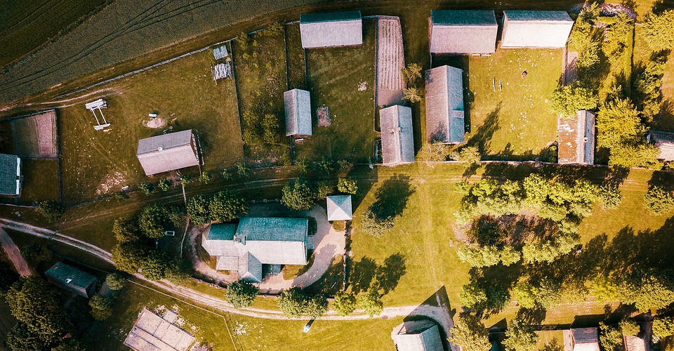
Mapping and land surveying are practices that are as old as written history. Drones have allowed this industry to reach even greater heights. With more advanced sensors and automated drone flight capabilities, more companies and industries than ever have started to recognize how they can leverage drone mapping for more efficient project planning and execution. The following are just some of the common applications of drone mapping.
1. Construction

The construction industry is the biggest potential market for drone mapping services. With an endless stream of construction jobs, the industry holds a lot of opportunities for professional drone mappers. Whether it’s for buildings, roads, or utilities, a detailed map or model can greatly help project managers in planning construction jobs. Since accurate length, area, and volume measurements can be made on these models, they can also be reliably used to estimate the costs needed to execute a project.
The usefulness of drone mapping doesn’t’ end once a construction project is underway. Drones have been used for periodic surveys of ongoing projects to update both management and stakeholders about the project’s progress. Maps and models can give a high level of details for these progress reports, even without having to physically visit the project site.
2. Mining
Mining firms are some of the most frequent customers of mapping professionals and land surveyors. Before a mining project kicks off, information on terrain and slopes will prove to be valuable in planning access roads and in assessing the potential blasting sites. Potential geological hazards can be identified ahead of time for either mitigation or avoidance.
The vantage provided by drone mapping is also very useful in monitoring both the safety and progress of an ongoing mining project. Subtle changes in slope or ground elevation can be precursors to potentially hazardous conditions, and the detailed models provided by drone mapping can help detect them. Detailed models are great for inventory management as they can be used to compute for stockpiles and aggregates.
3. Research
Environmental scientists and geologists have used drone mapping to conduct research in various areas, especially those that are difficult to access. Survey-based models can help track the movement of wildlife, the population in an area, or the health of vegetation. Models can also help geologists identify features such as domes, rivers, and faults. The best part is that these professionals can get all this information without having to go out in the field.
4. Land surveying
Land surveys have been traditionally done to define the legal boundaries of parcels of land. With drones, these land surveys can be done much faster and more accurately. While it’s easy to enough to do a ground-based land survey of a small lot of land, land developers and urban planned to need to have survey information on several acres of land will probably appreciate how quickly drones can get the job done. Since most drone mapping jobs can be done automatically, there is very little risk of drone mapping producing inaccurate results.
5. Agriculture
Agriculture is still an up-and-coming field for drone mapping, but it’s quickly becoming relevant. More accurately known as precision agriculture, the practice of using drones to survey vast acres of land allows farmers to assess crop health using data collected by highly sophisticated sensors. The data collected from precision agriculture surveys can be integrated with most farm management systems so that remedial actions can be implemented error-free.
The advantages of drone mapping
There are several good reasons for why mapping professionals are making the shift to drone use.
1. Automated and repeatable
Drone mapping involves the collection of a large amount of data at various points within the designated survey area. A good drone mapping software knows exactly how much data is needed, and where these should be collected. Thus, most drone mapping software platforms come with a flight mapping module. Using this feature, drone pilots can simply define the survey area or a flight path, and the drone will fly automatically.
The automated feature of drone mapping not only ensures that all necessary data is collected accurately, but it also allows a drone pilot to save the flight parameters for future use. Repeat surveys are often done to monitor projects or areas that are expected to change over time. Having a single set of flight parameters across different stages isn’t just convenient, but it also ensures consistency across different models.
2. Faster and easier
Back in the day, land surveys were done purely on the ground by measuring the distance and angles between points using total stations and handheld measuring devices. As you can imagine, this was a long and tedious process. Surveyors had to access different points in the survey area and spend several days up to several weeks doing the measurements.
In contrast, drones can cover several acres in just a matter of minutes. Mapping surveys rarely take several days to complete depending on the level of resolution of the model you want. It also doesn’t take a team to pull off a mapping job – in most cases, a single person piloting the drone will do. The drone pilot does not need to move around the survey area as long as the drone can fly within the legal range.
3. Cheap
It’s rather unfair to compare drone surveys to ground-based mapping methods as they have the advantage of aerial access. However, the only other alternative to do an aerial survey is to use a manned aircraft, typically a helicopter.
Although the accuracy and speed between a manned and an unmanned aerial survey should be similar, the difference in expenses will be like night and day. Between the cost of rental for the helicopter, the fee for an FAA-licensed pilot, and the fuel for the whole survey, a manned aircraft mapping survey can be easily ten times more expensive than a drone-based survey.
4. Safe
The less time that you spend out in the field, the less likely that you are to run into work-related hazards. Whether you work in forests and other deserted areas, or a construction site bristling with equipment activity, you will inevitably be exposed to hazards when you’re out in the field. With drone surveys you don’t even have to be in the thick of things – you can just take off and land your drone safely away from the survey area. Just make sure you get a good view of the area, as you’ll still need to maintain visual contact with your drone.
Introduction to drone mapping technology
When it comes to the technology to do drone mapping jobs, there are a lot of options out there. Which one you choose depends on your budget, level of technical skill, and the type of output and services you want to offer your clients.
Before we even talk about which drone you should buy, let’s go over all the basics of drone mapping so you can make an informed decision.
1. Photogrammetry vs. LiDAR
The objective of any drone mapping survey is to collect relevant data to generate a map or a 3D model of the survey area. While this model can be augmented with additional data such as thermal or near-infrared imaging, the foundation of all drone mapping jobs is an accurate 3D model of all the features in the area, such as buildings, utility lines, pipelines, and geological features.
How are these models generated? There are two common methods used today: photogrammetry and LiDAR. These two methods use vastly different technologies and equipment.
Photogrammetry is the use of a series of overlapping images and stitching them together to deduce the depth of individual features seen in the images. This works in the same way that our brains combine images from the left and right eyes to provide depth perception – by triangulating how an object appears from different perspectives.
LiDAR stands for “Light Detection and Ranging”, a technique by which a LiDAR sensor emits continuous pules of non-visible light. These pulses of light are then reflected by features in the survey area and are detected by the LiDAR sensor. Since the speed of light is constant both ways, the time it takes for each pulse of light between emission and reception can be used to determine the size and location of the features in the survey area.
Both methods are widely used in today’s mapping industry, with each one having its benefits and drawback. The strength of photogrammetry is in its simplicity. It only requires a drone that is equipped with a high-resolution camera and a GPS module – features that are already included in practically all high-end drones nowadays.
Aside from collecting dimensional data, photogrammetry can also capture high-resolution photos that can be draped over the model. Thus, 3D models and maps made from photogrammetry are more visually striking. If your use case focuses more on visual inspection, such as assessing road conditions or the degree of vegetation cover, then photogrammetry is the more appropriate solution.
However, the applications of photogrammetry are quite limited. Since it relies on visual images, it can only map features that visibly clear. This means that photogrammetry cannot be used when there are features hidden by shadows and cannot do mapping jobs at night. If you want to survey the topography of a heavily forested area, then photogrammetry won’t be of much help to you as it will only capture images of vegetation.
On the other hand, the fact that LiDAR does not depend on visible light makes it more versatile. It can map features in darkness and can even penetrate through canopy cover to generate topographic models. It’s also typically accurate to around 1 meter, which is a huge improvement to the usual accuracy of photogrammetry.
The biggest drawback of LiDAR is that it costs a fortune. Even just the LiDAR sensor can cost more twenty times the price of a prosumer-grade DJI drone. LiDAR sensors are also bigger and heavier, so you’ll likely need a drone with large payload capacity. Such drones are also going to be more expensive.
In summary, drone mapping using photogrammetry is a more accessible option. There’s a very little technological barrier to entry, although you’ll also have to limit the scope of services that you offer. LiDAR technology provides higher versatility and accuracy, but it literally comes at a price. The cost of a LiDAR setup isn’t something that a budding commercial drone pilot can afford, so it’s more recommended for professional mapping firms or those who have built up years of experience.
2. Fixed wing vs. Multirotor
In terms of the type of drone you’ll be using for mapping surveys, there are two equally valid schools of thought: fixed-wing drones and multirotor drones. Again, each option has benefits and drawbacks.
Multirotor drones are probably the ones that you’re used to seeing. Consisting of a frame and multiple (usually four) propellers, multirotor drones have become highly popular since they are very easy to use. They can take off and land anywhere, are highly maneuverable and can hover in place.
They are also pretty small, which makes carrying them around to do jobs easier. Since there are so many of these multirotor drones in the market from a variety of manufacturers, the competition has driven the price of multirotor drones way down.
The downside of using multirotor drones is that they have very limited flight times. Since the propellers of a multirotor drone provide both lift and thrust, their batteries have to provide much more power. If you are mapping a large area, this means that you will have to change the batteries after every 20 to 30 minutes. This is even more important for multirotor drones, as they will crash spectacularly if they run out of battery in the middle of the flight.
On the other hand, fixed-wing drones look more like a traditional winged aircraft. The shape of the wings of a fixed-wing drone generates a lift while rotors provide forward thrust. Since the rotors of a fixed-wing drone have to do much less work, their batteries last a good deal longer – typically around 45 minutes on a single battery cycle. This allows fixed-wing drones to cover larger areas on a single battery charge, which means they can finish mapping jobs faster.
Even if the battery of a fixed-wing drone run outs of juice mid-flight, its aerodynamic design will allow it to glide to recovery for a few hundred miles. Since its altitude loss is much slower, this allows the drone pilot to maneuver the drone to a safe landing spot.
However, a fixed-wing drone isn’t something we recommend for beginners. It’s much less maneuverable and cannot make sharp turns. A fixed-wing drone doesn’t give the drone pilot the luxury of hovering place while they consider their next move. They also require a runway for takeoff or landing, although some fixed wing drones made nowadays can be already be launched by hand.
Fixed wing drones are also typically larger, making them less portable. Since there are not as many fixed-wing drone models in the market, they are typically more expensive.
All things considered, it is probably easier for a drone pilot just breaking into the field to use a multirotor drone. It’s the more practical option, especially if you won’t be surveying areas larger than a few acres. For larger survey areas, a fixed-wing drone will be a worthy investment. Fixed wing drones are also uniquely suited for survey areas that are basically long corridors, such as for inspection of electrical lines and pipelines.
3. Ground Control Points
While a professional-grade drone already has the ability to “geotag” the photos or data that it collects during mapping, the accuracy of the onboard GPS module is still limited. Factors such as poor GPS signal and drifting of the drone due to winds can compound the error of GPS readings. If the application of the map or model you are producing requires a high level of global or absolute accuracy (such as property boundary and as-built surveys), then you’ll need to correct or avoid this inherent error.
The most traditional way to do this is to establish ground control points (GCPs). GCPs are highly visible marked targets distributed across the survey area, the locations of which are determined using highly accurate GPS receivers. These targets show up in the completed map and act as “anchors” to correct the rest of the map.
Conventional mapping wisdom suggests that at least five GCPs be established in a single survey area: one for each corner, and one near the middle. Larger survey areas may require a higher number of GCPs, although having more than ten doesn’t yield much improvement in terms of accuracy.
GCPs are technically simple and reliable. Even in an age where advanced technology is available for professional mappers, most of them still prefer the accuracy and dependability of ground-level measurements. A map or model based on ground-level measurements is very defensible, and GCPs are a great way of combining both traditional and advanced mapping methods.
However, establishing a high number of GCPs makes the mapping process much more tedious and time-consuming. Not only does it affect the manhours needed and the turnover time for each project, but it also means that surveyors spend more time exposed to field hazards. Thus, any reduction in the number of required GCPs would be a welcome relief for mapping professionals.
4. RTK vs PPK
In the past few years, drones designed especially for mapping have gotten outfitted with RTK or PPK modules. Real-Time Kinematic (RTK) and Post-Processed Kinematic (PPK) are just two different workflows that take advantage of the same technology.
An RTK or PPK-ready drone is equipped with an onboard module that is made to communicate with a stationary base station. While the drone flies around the survey area automatically geotagging the photos and data it collects, the base station also collects highly accurate locational data. By determining the distance between the base station and the onboard module, the GPS data collected by the drone is corrected to higher accuracy. PPK and RTK-enabled drones commonly claim to be able to provide accuracy to a centimeter level.
The difference between RTK and PPK lies in how the correction is applied. As its name implies, the RTK workflow does real-time corrections. Thus, the onboard RTK module and the base station needs to maintain constant communication while the survey is ongoing. On the other hand, a PPK workflow allows both devices to record all their data separately and apply a post-process correction algorithm.
The limitation of using an RTK workflow is that it might not work for all survey areas. Areas with a high number of obstacles such as buildings, bridges, houses, and mountains, may cut off the communication between the drone-mounted RTK module and the stationary base station. If this happens, the data is “classified as RTK-float,” and the accuracy benefits are effectively invalidated.
Most experts agree that PPK is the more versatile option. Since the base station does not need to communicate with the onboard module during the survey, the workflow is not disrupted even for obstacle-dense survey areas. Moreover, the data maintained by the PPK workflow is richer and provides that opportunity to compare the results of the present survey with past datasets. In terms of reliability and robustness, the PPK workflow is the more superior option.
The biggest hurdle to adopting an RTK or PPK workflow is the steep price of the associated equipment. While out-of-the-box drones can incorporate GCPs into their mapping workflow with little additional investment, an RTK or PPK-ready setup can be more than five times more expensive.
Again, we recommend the cheaper and simpler option for beginners. Mapping using GCPs can be a lot of work, but it provides the opportunity to learn about the fundamentals of aerial mapping. RTK or PPK workflows are a bit more complex and expensive, but the level of accuracy that they provide is something that any professional mapper should aspire for.
5. Other sensors
Aside from the typical mapping jobs using photogrammetry and LiDAR, drones can also be outfitted with more sophisticated sensors for a variety of applications. Radiometric thermal mapping is also quite common, while near-infrared mapping is becoming more and more common for precision agriculture.
Drones equipped with dual visual and thermal cameras can generate radiometric thermal maps that can highlight high-temperature and low-temperature spots. This is a useful tool for locating points of heat leakage, water leakage, weather damage, and roof degradation in houses and buildings. For utilities, thermal mapping can also help identify leaks along gas pipelines or damaged electrical lines. Damaged modules in vast acres of solar farms can be quickly identified by a quick aerial thermal scan.
Precision agriculture uses sensors that can capture images at different frequencies (typically near-infrared and red edge) to deduce useful data about crop health. Healthy and unhealthy crops emit and absorb different levels of energy along these frequencies and seeing how areas in a farm contrast with one another is an effective tool in identifying problem areas.
As you would expect, these advanced sensors can be very expensive. If you’re building a rig that can do thermal or precision agriculture surveys, then you can expect to spend somewhere around $5000 to $20,000. While it’s not something we can recommend for up-and-coming commercial drone pilots, they are great avenues for specialization.
If you’ve managed to build up substantial expertise in drone mapping, then going into specialized services is a great way to corner the market and earn higher profits. Specialization is pretty much the name of the game in today’s highly competitive drone services industry.
Minimum requirements for a mapping drone
Obviously, the features you want to have in your drone depends on the type of mapping service you’re aiming for. You can keep it as simple or as complex as you want. However, there are a few things that we would consider non-negotiable.
1. 4K camera
Nowadays, a 4K camera is considered a minimum for any type of professional drone work. While the output of mapping jobs is less focused on appearance, a high-resolution camera can still capture a greater amount of detail. This means that the features in the models produced by the survey can more accurately mirror their real-life counterparts. Of course, they will also look better. High-profile clients will expect nothing less.
2. Gimbal stabilization
A mapping drone will be in a constant state of motion while it shoots photos for your photogrammetry workflow. This means that an effective image stabilization mechanism is crucial to ensure consistent image quality. In this context, nothing beats the output quality of mechanical stabilization by a motorized gimbal.
Some high-end drones also have dedicated firmware for their gimbals, which allows for the transmittal of gimbal data such as pith and yaw angles. These can be integrated with GPS data for more accurate geotagging of individual points within photos.
3. Obstacle avoidance
Once you dial in the settings and survey coverage you want for your survey, the drone pretty much takes over piloting duties. Although you are still expected to pay close attention to the drone even if it’s flying autonomously, we can’t discount the possibility that your limited attention span will fail you at some point. When such a situation comes up, you’ll be extremely glad to have a drone that can detect and avoid obstacles on their own.
4. Long flight time
Limited flight time is the bane of all commercial drone pilots. Not only does it mean that you’ll have to buy and carry around a lot of spare batteries, but that there’ll be a lot of time wasted in having the drone fly back to you to get their batteries replaced. This can be particularly cumbersome when your drone has to fly thousands of feet to cover your survey area.
The best way to avoid such a problem, and for you to finish your mapping jobs quickly, is to invest in a drone with long flight time. Anything that can fly less than 25 minutes on a single battery cycle will be more trouble than it’s worth.
5. GPS stabilization
GPS plays several critical roles in a mapping survey. The most important is that it allows for photos and data to be “geotagged” or associated with a point in a geodetic reference system. Drones also use GPS location, along with gyroscopes and accelerometers, to stabilize the drone’s movement along its prescribed path.
Lastly, drones rely on GPS technology to activate any automatic flight modes. The drone simply refers to the instructions it receives from the controller and moves towards the set destination, all the while continuously collecting data.
Picking the best drone for the job
There isn’t a single best drone for the job, for the simple reason that there is such a wide variety of mapping services. Instead, we’ll recommend the best drone for each type of service. We’ll also provide budget options if there are any available.
1. Best drone for photogrammetry – DJI Mavic 2 Pro
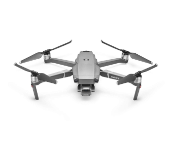
If camera quality is what you’re looking for, then you don’t need to look much further than the DJI Mavic 2 Pro. Although it lacks any RTK or PPK compatibility, it can boast of one of the best cameras in the prosumer drone market. The Hasselblad camera of the Mavic 2 Pro has a 1-inch CMOS sensor that can capture 20MP stills, has a wide ISO range, and an extra-rich color profile.
Another feature worth mentioning is the omnidirectional obstacle avoidance system. The Mavic 2 Pro was one of the first drones from DJI to receive this upgrade, allowing the drone to automatically detect and avoid obstacles in the forward, backward, upward, downward, and sideward directions. The 31-minute flight time should be more than enough to keep surveys efficiently moving along.
Best of all, these premium features are contained within an ultra-portable body that can be folded into roughly the size of a large water bottle. This is great for when you need to carry the drone on trips, or if you have to move from one take-off point to another.
Although the Mavic 2 Pro wasn’t specifically designed for mapping, it’s seamlessly compatible with common drone mapping software such as DroneDeploy and Pix4D.
2. Budget drone for photogrammetry – Holy Stone HS100
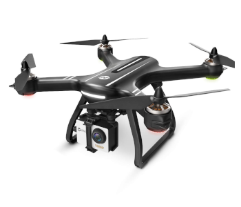
As good as the DJI Mavic 2 Pro is for photogrammetry, it’s still quite expensive as far as camera drones go. If you’re not quite ready to commit to such a high-end drone, then you can settle with the Holy Stone H100. This budget drone has a GPS function that can work with most drone flight planning apps and comes with a dedicated remote controller.
It is still a budget option, though, so it doesn’t come with some of the features that we’d prefer to have in a mapping drone. For instance, its camera only has 1080p resolution, although the 120° field-of-view is quite useful. Its flight time is also only limited to 15 minutes, which will make large survey areas challenging.
With its limitations, the Holy Stone HS100 isn’t exactly the drone that you can build a successful career as a drone mapping professional with. It’s a low-cost way to learn the ropes, though, and you might even be able to do small jobs with it. Consider it a drone to tide you over until you can afford to make the upgrade to a higher end model.
3. Best drone for RTK mapping – DJI Phantom 4 RTK
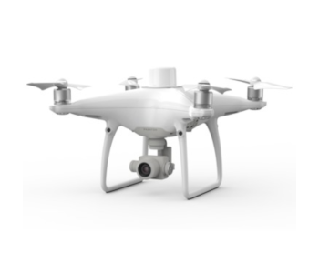
RTK technology is already complex enough as it is, so we like to take the simplest option. The Phantom 4 RTK is a turnkey mapping drone that comes with an RTK module and the D-RTK2 GNSS Mobile Station. It also has a dedicated controller that comes pre-loaded with the DJI GS RTK app, which has handly flight planning features.
The Phantom 4 RTK is one of the most user-friendly RTK-enabled drones. It requires minimal assembly and should be just as easy to use as any DJI drone. If you’ve had any experience flying a Phantom 4 drone before, then you should feel right at home with the interface of the Phantom 4 RTK.
Although DJI claims that the Phantom 4 RTK is compatible with a PPK workflow, feedback from many drone pilots appears to show the contrary. Third-party companies have even been popping up that offer modification services to allow the Phantom 4 RTK to work with PPK. This isn’t something we are eager to do, especially for an expensive drone like the Phantom 4 RTK.
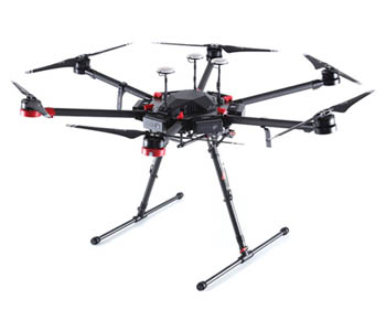
4. Best drone for PPK mapping – Yuneec H520 RTK
Its name makes it quite obvious that the Yuneec H520 RTK, but it was also designed to seamlessly shift to PPK. In fact, the Yuneec H520 RTK may be one of the most versatile mapping drones available today.
In addition to Yuneec’s signature hexacopter build, the H520 RTK comes with all the necessary mapping components: a mounted RTK module, a Network RTK Base Station, and a dual GPS-GLONASS module. If you have an existing Yuneec H520, Yuneec can even upgrade your unit to add RTK capabilities.
Aside from being able to switch between RTK and PPK, the Yuneec H520 also features hot-swappable payloads Whether you want to go for the E90 20MP high-speed camera or the CGOET thermal imaging camera, the H520 RTK is the perfect drone for a wide range of drone mapping applications.
5. Best fixed-wing mapping drone – senseFly eBee X
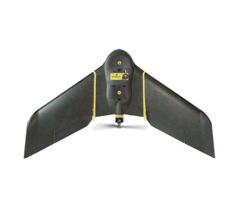
When it comes to professional-grade fixed-wing drones, senseFly reigns supreme. With years of experience making and flying fixed-wing drones, their lineup features some of the most popular options for many commercial drone pilots.
We chose the eBee X due to its sheer versatility and flexibility. Not only does it support a variety of payload options, but it can also be customized to function with PPK or RTK workflows. The eBee X was designed to work with the super-popular Pix4D mapping software. senseFly’s wide range of payload options, including the SODA 3D mapping camera and the Parrot Sequoia+ NDVI sensor, greatly augment the possibilities of what the eBee X can do.
As you would expect from a fixed-wing drone, the eBee X can fly up to an impressive 90 minutes on a single battery cycle. It’s very fast and is built with space-grade technology, making it very robust and reliable.
Although the senseFly eBee X gets stellar marks on performance, build quality, and versatility, it’s also one of the most expensive options in this list. With all the additional components and accessories, a mapping setup with the eBee X could set you back close to $15,000.
6. Best LiDAR sensor – YellowScan Mapper II
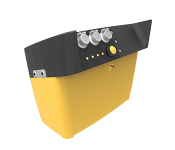
As far as we know, there hasn’t been yet a drone that was designed specifically for LiDAR surveys. Instead, what we have today are modular sensor setups that can be installed on popular drone models. At the top of this list is the Mapper II sensor from YellowScan, a turn-key LiDAR sensor that is compatible with many of the popular enterprise-grade drones. With a firmware designed for fully autonomous operations and an automatic georeferencing workflow, the Mapper II can greatly enhance the efficiency and accuracy of LiDAR mapping surveys.
The Mapper II has an effective range of 200 meters, which allows your drone to fly over the survey area from a safe altitude. It’s also equipped with RTK and PPK features that can interface with RTK base station to achieve centimeter-level accuracy.
If you really want to take LiDAR technology to the limit, then you purchase a few additional accessories for the Mapper II. It can be paired with an option 24 MP RGB camera for synchronized data collection. This is great for collecting surface data, which can then be draped over your LiDAR model. You can also buy the YellowScan LiveStation which can be used for real-time monitoring of LiDAR data as its generated.
While the Mapper II is an ibeo-based sensor, YellowScan also offers different LiDAR sensors using other technologies. For instance, the YellowScan Surveyor is based on VeloDyne VLP-16 and Vx-15, which is based on Riegl mini-Vux.
7. Best thermal imaging sensor – DJI Zenmuse XT2
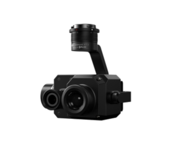
When it comes to thermal imaging, the competition is more between sensors rather than drones. In this context, the Zenmuse XT2 thermal imaging sensor from DJI has quickly risen to the top of the ranks. The radiometric thermal sensor of the XT2 is paired with a 12MP RGB sensor, allowing for the synchronized collection of both thermal and visual images. An IP44 rating means that this sensor is weather-resistant, making it a worthwhile addition to any of the drones in DJI’s lineup of enterprise-level M200 and M600 models.
The XT2’s radiometric thermal sensor has a high level of thermal sensitivity and a high thermal frame rate, allowing it to capture even the smallest temperature difference across space or over time. With a bunch of smart features such as a high-temperature alarm, heat tracking, and picture-in-picture options, the Zenmuse XT2 is one of the most advanced thermal imaging sensors out in the market today.
8. Best drone for precision agriculture – senseFly eBee SQ

The eBee SQ is another fixed-wing drone from senseFly, although this one is more geared towards precision agriculture. It has no payload interchangeability but is equipped out-of-the-box with the Parrot Sequoia+, the smallest and lightest multispectral sensor available today. By focusing on specialization, the eBee SQ manages to be much more affordable than the eBee X.
The eBee SQ comes with the eMotion Ag software, a complete software platform that provides flight planning, data management, and data processing features.
Despite its size, the Parrot Sequoia+ multispectral sensor is a superb piece of technology that is considered one of the best in the precision agriculture industry. It comes with four sensors: near-infrared, red-edge, red and green, and RGB. By using combinations of the data collected by the different sensors, various crop health indicators can be made available for crop management.
The data produces by the eBee SQ is compatible with most farm management systems and agricultural machinery so you can seamlessly implement remedial actions based on the survey results.
What to look for in drone mapping software
Once you’ve got the mapping drone all set, you’ll need to pick a good software platform to process your survey data. Owing to the popularity of drone mapping services nowadays, there’s not a huge market for drone mapping software. With so many choices, it can be hard to distinguish one from another. To help you in the decision-making process, then here are some of the most important considerations when choosing your drone mapping software.
1. Ease of use
What’s the point of using fancy software if you can’t figure out how to use its features? In modern software development, ease of use is considered one of the top priorities. Not all commercial drone pilot has the luxury of time or are naturally savvy with technology to master software platform with complicated interfaces. We suggest looking for a software platform with user-friendly features but doesn’t skimp out on the technical capabilities.
2. End-to-end solutions
Good mapping software should be able to help you through all the phases of a mapping project – from planning, data management, data processing, and publishing. Aside from the convenience of working within a single software ecosystem, this also ensures that you don’t run into issues with cross-platform compatibility of data and output files.
3. File export formats
Even if you’re using an end-to-end software platform, there may be times when you need other software, such as ArcGIS or AutoCAD, to post-process your map and model. You might also need to collaborate with your clients and other service providers, who could be using software different from yours. This emphasizes the importance of using a platform that allows you to export your output to a variety of file formats without loss of integrity.
4. Pricing model
Most software packages nowadays are available via a monthly or annual subscription, although there are still a few that only require a one-time payment. Although subscription-based pricing can get expensive in the long run, you enjoy the benefits of regular software updates and always-available customer support. If you’re just starting, we recommend looking for software that offers a free trial for a limited time, so that you know what you’re getting into.
The best mapping software packages
1. Pix4D
You’ve probably noticed that we’ve already mentioned Pix4D a few times in the previous sections of this article. This was hardly intentional and is only a result of the fact that Pix4D is one of the most widely used software platforms for commercial drone mapping. Pix4D is a safe bet no matter what drone you have or what field of drone mapping you’d like to get into – they are compatible with the eBee drones and DJI’s line of enterprise-grade drones.
With more than a decade of experience coming up with software solutions for the drone mapping industry, the team behind Pix4D has created a huge selection of specialized software modules for different mapping applications. This robust software package can also export files in a variety of formats.
However, Pix4D is also one of the more expensive mapping software options. Since the platform is so rich with options, it also isn’t the most user-friendly.
2. DroneDeploy
If we’re talking about ease-of-use, then DroneDeploy is considered a superior choice. On top of its rich features and compatibility with other industry-standard 3rd party apps, the team behind DroneDeploy has spent the past few years making the platform as easy to learn and intuitive as possible. By leveraging on the abilities of 3rd party apps, DroneDeploy does not need to have as wide a selection of special modules.
DroneDeploy is more recommended for beginners, considering its focus on accessibility. It’s also one of the more affordable options and even comes with a 30-day free trial period.
However, DroneDeploy is more limited in terms of features and compatibility with other file formats. For these reasons, DroneDeploy isn’t as popular of an option for enterprise-level mapping applications.
3. PrecisionHawk

The PrecisionHawk platform has become very popular in the past few years because of one major move: back in 2017, the development made PrecisionMapper a free, open-source software. This was done by the company to promote innovation and to give back to the drone mapping community.
There are some limitations in the free version, though, such as only being able to process 60 survey projects per year. All data processing is cloud-based, so you don’t even need to have a powerful computer. PrecisionMapper is probably one of the most comprehensive mapping software platforms that come free. On top of model and map generation, the software allows you to make volume calculations, generate contour maps, and create NDVI maps for crop health assessment. GCPs can also be integrated to correct an existing map.
By paying for the full version of PrecisionMapper, you get to enjoy more advanced processing algorithms such as orthomosaics, water pooling, or tree crown delineation. These are highly specialized functions and are typically only used in high-level mapping applications.
Aside from PrecisionMapper, there are several other modules under PrecisionHawk’s paid subscription plan. The PrecisionFlight mobile app can be used for planning and execution of flight missions, while the PrecisionViewer desktop software is primarily used to view mission data and make annotations.
This “modular” design of the PrecisionHawk platform does make it quite complicated, which might be overwhelming for beginners. Of course, the fact that they offer a free module means that you can try it out whenever you want.
4. RAPID by DroneMapper
In a departure from the other entries in the list, the RAPID software from DroneMapper is just a simple photogrammetry software. They offer a completely free version that limits the number of photos you can process to only 150 images per project. This is probably for the best since RAPID does not offer cloud-based processing. For a modestly sized project, you probably won’t need a very powerful computer.
If you’re satisfied with the free version of RAPID, you can opt to pay for the license. This will give you access to REMOTE and REMOTE EXPERT, more advanced versions that allow you to process a much greater number of aerial images and adjust your models using GCPs. The paid versions also allow exporting to more file formats.
The biggest benefit of RAPID is that even its free version is a perfectly capable survey data processing software. It’s also one of the most beginner-friendly options available today. If you’re just starting in your career as a professional drone mapper, we highly recommend giving the RAPID software by DroneMapper a try.
Other things you’ll need
Now that you’ve got the hardware and software locked, it’s time to take care of the legal requirements of starting a career as a commercial drone mapper. If you think you’re done shelling out money to get your career off the ground, then we’ve got bad news for you: there are a few more things you’ll need to spend on. Don’t fret, though. After this step, you’ll be all set to start earning money.
1. Register your drone
According to FAA rules, all drones that weigh between 0.55 and 55 lbs. need to be registered whether they are to be used recreationally or commercially. If your drone is meant for mapping, then it almost certainly falls within this range. The registration process is pretty easy – everything you need to do can be done through the FAA’s DroneZone website.
You need to be at least 13 years of age and be a US citizen or a legal permanent resident to register a drone. You will need to provide a valid email address, a mailing address, and the make and model of your drone to complete the registration process. You will also need to pay a $5 registration fee.
Once you have received your unique registration number, it must be marked clearly on the body of your drone. The FAA guidelines state that the registration number must be easily visible, so you just put it on a sticker or engrave it somewhere conspicuous. Take note that the drone registration is only valid for three years.
2. Get a Part 107 license
This is what sets apart commercial drone pilots from those who fly just for fun. Since 2016, the FAA has required all drone pilots to get a Part 107 license before they can fly their drones for profit. This allows the FAA to maintain a database of all commercial drone pilots in the US and to adjust stricter flight restrictions and rules for those who have their licenses.
Getting a Part 107 license is probably the most effort-driven part of starting a career as a professional drone pilot. The main requirement to get the license is for you take and pass the Part 107 knowledge test – a 60-item multiple choice test that covers topics such as reading sectional charts, interpreting weather reports, and understanding how loading affects drone flight performance. There’s also the $150 testing fee that you will have to pay.
The good news is that there is a 90% passing rate for the Part 107 knowledge test. If you’ve done your preparations, there shouldn’t be any reason for you to fail. After passing the test, you need to go through a TSA background check before finally receiving your Part 107 license.
Having a license means adhering to all the Part 107 rules and regulations. It’s also only valid for two years, after which you’ll have to take a recurrent knowledge test.
3. Get insurance
Being a drone mapping professional means flying your drone in places that are unfamiliar to you. You might have to fly over tracts of undeveloped land, a mountain range, or a remote forest. You might have to inspect critical structures such as pipelines and communications towers. With more unfamiliarity comes a higher chance of getting into an accident. When you’re in the line of professional drone flight, you need to have a backup plan in case an accident happens.
There are two types of insurance plans recommended for drone pilots: drone hull insurance and liability insurance. Drone hull insurance covers just the cost of your drone and accessories. In case your drone crashes, a drone hull insurance provides financing so that you can have your equipment repaired or buy a new set. You can also get a separate payload insurance for high-value payloads such as thermal cameras and LiDAR sensors.
Liability insurance is what you should be focusing on, as it will likely be the more expensive insurance you will take. This insurance covers the cost of any consequences that may come as a result of a drone-related accident, such as damage to the property of others and injury to people. As you can imagine, a liability insurance plan has to have a much larger coverage – after all, damaging someone else’s car or paying for someone’s hospital bills will probably be more expensive than your drone.
For beginning drone mapping professionals, a starting coverage of around $500,00 is considered standard. A huge business can have a much large coverage of up to $10 million.
Combining the premiums of both drone hull and liability insurance, you can expect to pay around $2000 to $2500 annually. For a more economical option, you can instead get on-demand coverage from companies such as SkyWatch and VeriFly. These companies will provide coverage only when you need it, so you don’t have to spend as much money paying an annual premium.
How much should you charge?
Now that everything’s all set, you can start marketing your drone mapping services to landowners, real estate agents, construction companies, mining firms, and research firms. However, you’ll need to decide on the rates that you are going to charge before you can start advertising. How much should you be charging?
The best way to be competitive in any market is to look at how much your competitors are charging. Right now, more than 30% of drone mapping professionals charge by the hour – specifically, with an hourly rate of $150. A vast majority of mapping service providers charge an hourly rate between $100 to $200. This is a pretty narrow range, so feel free to play around with what works best for you.
It’s also worth noting that different clients pay different rates for mapping services. The most profitable clients are oil and gas firms, as they can be charged up to $195 per hour. Agriculture and construction firms are also good customers, as they can pay $160 to $170 per hour.
Don’t forget to add a surcharge rate, should there be additional expenses associated with your job, such as if you have to travel and stay in remote locations. You might have to start in the low end of the range if you’re just starting out. If you can corner a market through excellent results, you might be able to join the ranks of successful drone pilots who can earn up to $200,000 per year.
Final thoughts
Drone mapping is a dynamic and exciting field and is considered one of the highest-potential industries for drone services. There’s quite a bit of a barrier of entry to it, both technically and financially, but you can look at it as an opportunity to enter a field that is not yet saturated.
We hope that this detailed guide we have come up with can help you take that first step towards becoming a drone mapping professional. There are a couple of good pieces of advice that we have written about in the past, such as how to start your drone-based business and how to come up with a business plan. If you haven’t checked out those articles yet, they are definitely worth your time.
Just as with any business, starting a drone mapping enterprise is going to be challenging. You’ll need to learn a lot about drone mapping technology and techniques, not to mention the fact that you’ll also be spending quite a lot of money. The returns are worth it, though. If you can get a good client, you might even be able to earn back your initial investment within a year.