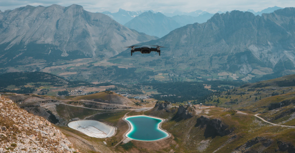
How to Survey a Tower with a Drone

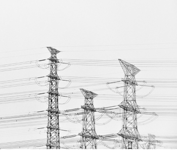
As one of the more lucrative commercial drone applications, tower inspection simply makes sense. By using drones, a tower inspection job can be done more quickly, gathering a ton of information within several minutes and without exposing personnel to fall or electrical shock hazards. Doing aerial inspection via drones is also significantly cheaper than doing the same job with a helicopter.
As anyone can tell, doing a tower inspection isn’t something that just any drone pilot can do. This is highly specialized work that requires a specific set of skills and dedicated hardware. Here’s our quick guide on what you need to know to do a drone tower inspection.
Define your objectives
Before laying out a plan for how a drone tower survey will be done, it is important to know the objectives of the survey. This is something that needs to be established with the client, as it can also determine how long the survey will take, what the plan will be, and what type of hardware will be needed.
To help in establishing objectives, here are just some of the most common reasons why a company will ask for a drone tower survey.
• Checking for structural damage
The most common reason for surveying a tower is to help check for signs of structural damage. This can be done as part of the regular maintenance of the tower or as preparation for any large-scale repairs or additional work. By checking for structural damage, utility companies can tell how dangerous it will be to send people up the tower to do repair or further inspection.
Structural damage can manifest in several ways. Not all of them may visibly obvious and may only be identified through thermal imaging. How thorough the inspection needs to be is something that needs to be agreed with by the client.
• Identifying environmental hazards
In some cases, tall towers can inadvertently become habitats for birds and bees. While this is typically not a problem in small instances, there is always the possibility that the homes of these flying animals can catch fire and cause long-term damage to the tower. By identifying these hazards during an inspection, a team can move in to have them removed and transferred to somewhere that’s safer, both for the animals and the tower.
• Pre-work inspection
Every now and then, a tower needs to be upgraded or repaired. This will require major work at high altitudes. With so many hazards and other unpredictable factors involved, utility companies will go to great lengths to make sure that they are well-prepared.
One of the best ways to do pre-work planning is by flying a drone around the tower to generate a 3D model of it. The 3D model can then be used to make measurements, prepare new or replacement parts, and assess how much time and manpower will be needed to complete the job.
A good 3D model is extremely valuable in that it’s fully navigable and infinitely measurable. 3D modeling is an entirely separate skillset to simply flying a drone. As far as commercial drone services go, it is one of the most specialized and lucrative.
• Part of regular maintenance
Even if nothing seems to be wrong with the tower, a utility company can still ask a professional drone pilot to do a quick flight around it as part of a regular routine. This is the best way to catch wind of any potential problems and to step in as necessary. Depending on the client, a regular tower survey can be as detailed as they want to be.
Anticipate the challenges
There are several good reasons for why a tower survey isn’t something that a beginner drone pilot should do. Flying in a wide-open space is one thing but flying at extremely high altitudes close to critical infrastructure is something else. These are just some of the reasons why a drone tower inspection can be quite challenging.
• Electromagnetic interference
One of the unique hazards of flying so close to a tower is the massive electromagnetic signals that it emits. For reference, any device that conducts electricity emits electromagnetic interference, the intensity of which is proportional to the amount of current that flows through the device. From this statement alone, it’s easy to imagine how intense the electromagnetic interference near a tower can be.
The interference can easily disrupt the communication between the drone and your remote controller. When you’re flying close to a tower, even a momentary loss of control can be disastrous.
Although some drones offer electromagnetic shielding, the best safety measure is simply to avoid flying too close to the tower. For this reason, you will need to use a drone with a high-resolution camera with some form of zoom function.
• Guy lines
Guy lines are wires that extend from the ground to the top portion of a tower that helps its stability. These guy lines can be very thin and hard to see, especially if you’re contending with the glare of the sun. Guy lines may also not be visible enough to be detected by a drone’s obstacle avoidance system.
When flying around towers with guy lines, it is best to keep a safe distance from them. A common strategy is to determine the location of the guy lines and only fly your drone vertically from a take-off spot. It will also help if you keep your drone located between you and the tower always to maintain optimal visibility.
• Wind
To survey a drone, you typically will need to fly above the 400-foot altitude limit that drone pilots typically follow. The main problem with flying at higher altitudes is that winds also tend to get stronger up there. To help maintain stability, it is often recommended to go with bigger drones with more powerful motors. Ultra-portable drones are still usable but may require a higher degree of pilot input to keep stable.
• Airspace restrictions
As a commercial drone pilot, you need to make sure to follow the Part 107 airspace rules. When it comes to flying near tall structures, drone flight is allowed to go beyond the 400-foot altitude limit if it is done within the 400-foot range of the structure. This is a pretty generous allowance, but it would still be prudent to place a demarcation around the 400-foot zone in your map.
• Battery life
Depending on the height of the tower you are surveying, it can take two to four minutes for a drone to gain altitude to the tower’s highest point. Since you’ll be gathering data or taking photos along the way, then it’s probably going to take much longer than that.
This could be problematic if your drone can only fly less than 20 minutes on a single battery cycle. By the time you reach the top, you might have already consumed half the battery. For this reason, it’s best to go with a drone that can fly at least 25 minutes on a single cycle.
Choose a suitable drone
Now that we know the typical objectives of doing a tower inspection survey and the challenging conditions we may have to face, we can come up with a more informed decision on which hardware is suitable for the job. We’re mostly looking for drones with good flight stability, strong transmission technology, responsive controls, and customizable payload. Here are just some of the best options:
1. DJI Matrice 210 V2
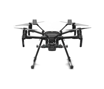
Easily one of the most powerful drones in the market today, the DJI Matrice 210 V2 is a technological wonder. This specific model comes with the capacity to support two gimbals, making it an exceptionally versatile tool. Combine this with the Zenmuse line compatible payloads and you have the recipe for a drone that can survey just about any tower.
The signature OcuSync 2.0 transmission system is one of the latest innovations developed by DJI, giving the Matrice 210 V2 an effective range of up to 8 kilometers. The drone comes with front, upper, and bottom sensors that can sense and avoid obstacles. It even has the AirSense feature, an ADS-B receiver that warns the pilot of any nearby manned aircraft.
If you’re an experienced drone pilot who seriously wants to go into drone inspection, then there are probably one or two other drones out there that can rival the Matrice 210 V2. It’s a very expensive drone but can quickly pay for itself.
2. Yuneec H520
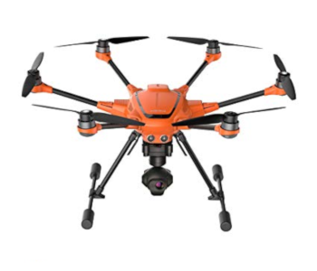
The H520 is Yuneec’s top-of-the-line professional-grade drone. Sporting the usual hexacopter form factor, what makes the H520 distinct is its ability to accommodate different payloads. Yuneec’s payload selection is quite limited but has useful entries like the CGOET thermal camera and the E50 high-resolution camera.
The payload system of the H520 is interesting in that it features a hot-swappable connection. This means that swapping from one payload to another takes only a few seconds and doesn’t even require powering down the drone. This is a very convenient feature to have when you’re out in the field and have your client breathing down your back.
The ST16S remote controller that comes with the drone has a few features useful for tower inspection. A built-in DataPilot software system can be used to quickly plan flight paths for 3D mapping, although we imagine its utility may be limited for vertical structures.
With its six rotors, the Yuneec H520 is certainly one of the most stable drones you will ever fly. This is a huge drone that has been extensively used in industrial applications. What it lacks in portability, it makes up for in sheer power and versatility.
3. DJI Mavic 2 Enterprise Dual
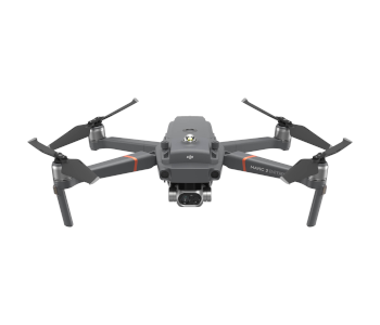
The Mavic 2 Enterprise may not have received much fanfare back when it was launched, but that’s understandable. Not only is it more expensive than other Mavic drones, but it comes with features that clearly have been designed for specialized professional drone pilots.
In the realm of tower inspection, the Mavic 2 Enterprise Dual version is certainly the more useful. The ‘Dual’ moniker comes from the fact that the drone has side-by-side optical and thermal cameras. This allows for thermal imagery to be overlapped with optical imagery, allowing for better identification of thermal anomalies.
On top of thermal imaging capabilities, the camera of the Mavic 2 Enterprise also has 2x optical zoom and 3x digital zoom. This will certainly come in handy if you don’t want to fly your bird too close to a tower.
With its compact design, one can dismiss the Mavic 2 Enterprise Dual as a drone that’s too small to fly near a tower. It may not have the power of larger drones, but its suite of sensors can keep this lightweight drone stable. With eight high-resolution vision sensors and two infrared sensors, the drone can detect and avoid obstacles using the Advanced Pilot Assistance System.
Use special tower inspection software if needed

While doing a visual inspection and thermal imaging of a tower can be done manually, collecting imagery data for 3D modeling is something that needs to be done with special software. This is the only way for you to make sure that you capture the right number of photos with the proper degree of overlap to generate a coherent and accurate 3D model.
The good news is that there are now a lot of drone mapping software platforms that are designed for such a job. On top of mind is Pix4D, an all-around platform for planning automated drone operations and data processing. It’s one of the best-known platforms for drone mapping and is used by industries and companies the world over.
DroneDeploy is another company with a similar model for providing all-around solutions to professional drone pilots. Much like PiX4D, the DroneDeploy platform can also be used at all points of the tower inspection job – from planning, execution, data gathering, and processing. Most of the data processing is cloud-based, allowing for a quick turnaround that is not limited by the hardware you have at home.
If you just need an app for fleet management, then KittyHawk is a good option that does away with all the features you’re not going to need. The app can be used for flight planning, flight logging, and for securing airspace authorization from the FAA. The app also provides live-streaming capabilities, in case the clients request to see the live video feed from the drone’s camera.
Doing a drone tower inspection can be particularly challenging because there can be more than a dozen factors that you need to consider and hazards to watch out for all at the same time. By making use of technology designed especially for the purpose, you can eliminate some of these stressors and focus on delivering high-quality results.
Final thoughts
Out of all the possible commercial applications of drones, surveying a tower is likely to be one of the best-paying. However, don’t expect a large utility company to call you up if you don’t have a lot of experience yet. With the integrity of critical infrastructure on the line, clients in this field will likely get in touch with those that have the proper equipment and expertise.
Experience is something that you will have to build on over the years, but we hope that this guide can help you start off on the right foot. Building a career as a drone pilot in tower inspection will be tough, but the effort pays off when you achieve success.