
10 Hard or Tricky Questions in the Part 107 Test and How to Answer Them

For aspiring commercial drone pilots, the Part 107 knowledge test is, by far, the biggest hurdle they need to overcome to get their Remote Pilot Certificate. While most of the questions in the knowledge test are pretty straightforward and can be answered with some ample studying, there are still certain questions that can throw test-takers for a loop. Some of these questions have come up again and again, according to the feedback from several people who have taken the test.
Below are the ten hardest or trickiest questions that can come up in your Part 107 test, and a short discussion on how to answer each one of them. Take note that the figures in the questions below may not be exactly the same as the ones you’ll find the actual test, but the logic and reasoning behind the answers are still similar.
1. What is the upwind direction of Runway 27?
A. East
B. West
C. North-West
This is actually a pretty simple question, but the concepts needed to answer this correctly are rarely discussed. It’s also worth analyzing how runway numbers relate to their direction as more complex questions can be formulated using the same concept,
Basically, the number of a runway corresponds to the direction of runway’s magnetic azimuth. In our example, the magnetic azimuth of Runway 27 is 270°. Similarly, the magnetic azimuth of Runway 16 is 160°, and that of Runway 18 is 180° – you get the point.
Now, a runway can normally be used in both directions. Thus, each end of the runway is labelled differently. In our example, Runway 27 will be labeled 90 on the other side. For this reason, a clear runway number must be announced when an airplane is about to land. To make this matter very clear, each digit in the runway number is pronounced individually during radio communications.
The upwind direction of a runway is the direction at which an aircraft will approach it. In our example, the upwind direction of Runway 27 is directly to the west. Conversely, its downwind direction is to the east.
2. According to today’s weather report, there will be a ceiling at 700 feet. Up to what maximum altitude are you allowed to fly your drone?
A. 400 feet AGL
B. 200 feet MSL
C. 200 feet AGL
In aviation and meteorology, a ceiling is defined as the altitude of the base of the lowest clouds relative to the ground. Weather reports can also describe the ceiling as “unlimited” if the skies are clear of clouds.
According to FAA rules, you must maintain a minimum distance of 500 feet from the ceiling. This supersedes the rule on maintaining a maximum altitude of 400 feet AGL. Since the ceiling is measured relative to the ground, the AGL altitude is more relevant in this situation. Thus, if the ceiling is 700 feet measured from the ground, then the maximum altitude you are allowed to fly your drone is 200 feet AGL.
3. What is the floor, in MSL, of the Class E airspace surrounding the Garrison Municipal Airport (D05)?
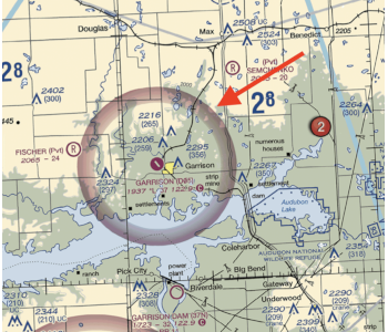
A. 700 feet MSL
B. 1937 feet MSL
C. 2637 feet MSL
If the question were asking for the floor of the Class E airspace near Garrison in AGL, then this would be a no-brainer. After all, the thick magenta line surrounding Garrison indicates that the Class E airspace defined by the airport has a floor at 700 feet AGL. However, the question is asking for the floor in MSL. This means that we will need to determine the elevation of the terrain in this region.
Since the airport defines the Class E airspace, the best representative for the terrain elevation would be airport itself. Thankfully, the label for the airport in the sectional chart helpfully provides this information. According to the label, the airports sits at an elevation of 1937 feet. This means that the Class E airspace defined by the airport will be measured relative to this elevation.
Adding 700 feet AGL to 1937 feet, we come up with the elevation 2637 feet MSL. This type of question may not have much of a practical application since drone pilots typically look at altitudes at an AGL scale, but it does come up a lot in the Part 107 knowledge test.
4. You are tasked to do a drone inspection of a communications tower located around 3 SM NW of the Mason Jewett Airport. Up to what maximum altitude are you permitted to fly while doing the inspection?

A. 400 feet AGL
B. 701 feet AGL
C. 1204 feet AGL
According to Part 107 rules, you are only allowed to fly up to a maximum altitude of 400 feet AGL when flying in an open area with no tall buildings or obstacles. However, you can go past this limit when flying within 400 feet of a tall structure.
The tower that this question is pertaining to, northwest of Mason Jewett Airport, has a maximum height of 301 feet AGL. Since the tower qualifies as a tall structure, a drone is allowed to fly 400 feet above its highest point. If you fly your drone directly above the highest point of the tower, you can fly it up to a maximum altitude of 701 feet AGL.
5. During a test flight, your drone stalls while making a sharp turn and crashes right into some bushes. While all of the parts of the drone remain intact, you notice the arms of the drone has become slightly bent. What is the best course of action?
A. Follow the manufacturer’s recommendations
B. Do a test flight at low altitude
C. Send in the drone immediately for repairs or replacement of parts
These are the types of questions where, practically speaking, there are no wrong answers. Each one of the choices is a reasonable response to the crash and the observed damage. However, the Part 107 knowledge test is designed to only have one answer for each question. This means that you’ll have to pick out the BEST answer, even from choices that are all seemingly valid.
In this case, the Part 107 rules do not have any provision on what licensed drone pilots should do when they observe some damage in their drones. Neither do they require a standard condition for the drone before you are allowed to fly it. Instead, the FAA always defers to the manufacturer’s recommendations. This applies in pretty much all parts of the drone – batteries, propellers, and software, among others.
6. While flying near the Cooperstown Airport and monitoring the CTAF, you receive an announcement of an aircraft midfield right downwind of Runway 13. What would the current position of the aircraft be relative to the runway?
A. North-East
B. South-East
C. South-West
To answer this question, we need to recall the concept of a runway’s upwind and downwind directions. Since the runway is numbered 13, its magnetic azimuth aligned along the 130° angle, facing South-East. This means that the downwind direction is North-West. However, this pertains to the direction is flying and not its position.
According to the announcement, the aircraft is flying downwind at the right of the runway. When determining which is right or left, it is important to consider the runway’s orientation. In our case, since the runway is facing the South-East direction, the area to its left is North-East, and the area to its right is South-Wast. Thus, we can conclude that the aircraft is in the South-West relative to the runway and is has a current heading of North-West.
7. What is the minimum altitude you must fly in the quadrant shown in the sectional chart below to clear all the obstacles in the area?
A. 210 feet AGL
B. 2100 feet AGL
C. 2100 feet MSL
Each quadrant in a sectional chart is labeled with large numbers that correspond to the Maximum Elevation Figure (MEF). This is the altitude of the highest obstacle, natural or man-made in that quadrant.
Since MEF numbers have to be standardized across different quadrants, they are measured from the sea level – that is, MEF numbers give the altitude of obstacles in MSL. In this case, a drone flying in this quadrant needs to fly above 2100 feet MSL to clear all the obstacles in the quadrant.
8. When is pressure altitude equal to density altitude?
A. Under standard conditions
B. When there is a temperature inversion
C. At sufficiently high altitudes
To answer this question, it would be best to define the concepts of pressure altitude and density altitude. Pressure altitude is a standard aviation term that refers to the theoretical altitude where the atmospheric pressure is equal to 29.92 inHg. You may recall that this figure is the standard atmospheric pressure at sea level. However, the actual pressure at sea level may vary based on atmospheric – temperature, the time of day, precipitation, or the presence of low-pressure fronts. Thus, the pressure altitude could be above, below, or equal to sea level.
The formal definition of density altitude is the “pressure altitude corrected for nonstandard temperature variations.”. That sounds like a mouthful, so let us break it down for you in simpler terms. Density altitude is essentially a simplification method that reduces variations in pressure and temperature into a single number. Since both pressure and temperature play a role in how an aircraft performs, the density altitude provides pilots with a quick reference to assess the level of flight performance they should expect under current conditions.
From the very definition of density altitude, we can deduce the answer to this question. Since density altitude is merely pressure altitude corrected because of nonstandard variations, it can be reasoned that the two terms are equal when conditions are standard. In aviation, standard conditions are a temperature of 15 °C or 59 °F, and a pressure of 29.92 inHg.
9. What is the CTAF for the Mason Jewett Airport?
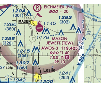
A. 119.4
B. 122.8
C. 122.7
While this isn’t such a hard question, this is the perfect opportunity to learn about CTAF and the difference between a controlled and uncontrolled airport. In our example, the Mason Jewett airport is represented by a magenta symbol. This means that this is an uncontrolled airport, or an airport with no control tower or air traffic control (ATC) unit.
In uncontrolled airports, pilots are expected to self-announce their position or their intention. Drone pilots don’t necessarily have to do this, but they are encouraged to tune in to the CTAF – the radio frequency that allows them to listen in on self-announcements. In sectional charts, the CTAF for each airport is indicated by a number next to a “C” bounded by a magenta circle. For this case, the CTAF for the Mason Jewett Airport is 122.7.
10. In the sectional chart, there are two military training routes visible, labeled IR146 and IR147. What do the numbers on the labels mean?
A. The groundspeed of the aircraft traveling along the route
B. The military training route is above 1500 feet AGL
C. The numbers are randomly assigned
In sectional charts, military training routes are indicated with either an IR or VR prefix. The only difference is that IR routes are flown under air traffic control, while VR routes are not. For drone pilots, this distinction is not so important.
What you need to take note of is the direction of the military training route and the numbers that follow the prefix. Military training routes numbered with four digits correspond to routes that are flown below 1500 feet AGL, while those with three digits correspond to routes flown above 1500 feet AGL. In our example, the IR146 and IR147 routes are above 1500 feet AGL – hardly a concern for drone pilots.
However, if you do spot a four-numbered MTR in the area nearby your planned drone flight mission, you should exercise caution. Military aircraft can fly by at speeds exceeding 250 knots, which will hardly give you much time to react and move out of the way. We recommend keeping out of these military training routes completely.
Final thoughts
As you may have noticed, most of the questions in this list refer to sectional charts in some form. Sectional charts can seem very foreign and unfamiliar to people who have never taken a look at one, so it’s really important for you to know sectional charts in and out.
The FAA can throw a lot of tricky questions your way, mostly involving the difference between AGL and MSL altitudes and orienting yourself on a map, but you just need to take your time and think things through. Hopefully, our list of some of the toughest questions you can expect from the Part 107 knowledge test has helped you in your preparation.