
LiDAR Technology and Its Interesting Applications

Many technology insiders and experts believe that, in the near future, data will be more valuable than money. For this reason, there are so many initiatives around the world to come up with better ways to collect data and to process them and derive useful information.
One such method uses a technology called LiDAR. This is an imaging method that can turn real-world objects into digital assets. However, the capabilities of LiDAR go well beyond simple 3D modeling. Let’s check out the more interesting ways in which LiDAR is used to see how revolutionary this technology can be.
What LiDAR?
LiDAR stands for Light Detection and Ranging. It is a time-of-flight method that uses active pulses of non-visible light to create 3D maps of a device’s environment. These pulses of energy bounce off any solid objects in the surroundings and are received by a separate receiver. The time it takes for the energy to reflect from solid surfaces is then processed as data to determine the shape, size, and location of objects surrounding the LiDAR device.
LiDAR has several advantages over other mapping technologies. It is fast, extremely accurate, and does not rely on visible light to perform its function. As it does not collect images, data processing in LiDAR also isn’t as resource-intensive as image-based 3D mapping like photogrammetry. As we shall see later on, the accuracy of LiDAR has made it the ideal method for some high-level applications.
LiDAR on your phone?

LiDAR modules became much more accessible when they came out as a feature of the iPhone 12 Pro less than a year ago. This was a huge departure from our assumption of LiDAR as some high-end piece of technology only used in industrial or commercial environments.
The LiDAR sensor in the iPhone 12 Pro may be tiny but it certainly has its uses. One of the primary applications of the LiDAR sensor is to create a quick 3D model of an interior space using the Canvas app. There are also several iPhone apps that use the LiDAR sensor as a 3D scanner for small objects.
As more app developers explore the possibilities of LiDAR, we can expect more ways in which the technology can be exploited. There is certainly so much more that can be done, particularly in the field of AR or augmented reality. If the iPhone 12 Pro experiment is successful, we can also expect LiDAR sensors to be staple features in other smartphones moving forward.
8 interesting applications of LiDAR technology
Putting LiDAR sensors in the hands of smartphone users is certainly an achievement for the technology. However, this would not have happened if the potential of LiDAR had not already been explored by researchers, data scientists, and tech designers through the past decades. Here are some of the more interesting and lesser-known ways in which LiDAR is being actively used.
Bathymetric mapping
The use of LiDAR for mapping lands, forests, and urban areas is already highly documented. However, scientists have also been using LiDAR to make 3D maps of the ocean floor. This field of study, called bathymetry, helps in the management of shallow coastline communities and in monitoring the health of marine environments.
LiDAR modules used for bathymetry are not the same ones used for terrestrial mapping. Instead, they use laser light close to the blue-green wavelength to better penetrate through the water.
Before LiDAR, bathymetry was done using acoustic methods. LiDAR is a vast improvement to this technology because it is faster can capture data at much higher levels of precision. With LiDAR, it is now possible to differentiate between different types of seabed (such as either sand or rock) using remote sensing methods.
Bathymetric surveys can be done using an airborne module. This makes it easier to cover large areas compared to ship-based acoustic methods.
Crime scene documentation

Documenting a crime scene can be a daunting task because it involves taking note of lots of very small details in a short amount of time. In the past, this was done by simply taking photographs. This method is imperfect and can result in some crucial pieces of evidence getting overlooked.
For these reasons, many law enforcement agencies and firms that offer this type of service are shifting towards LiDAR for crime scene documentation. A LiDAR sensor can be set up in the middle of a crime scene and allowed to gather data automatically. Within a few minutes, the sensor can gather enough data to reconstruct a 3D model of the crime scene.
Aside from retaining the appearance of the crash scene, the great thing about the 3D model is that it can be analyzed and measured endlessly. In the past, painstakingly taking measurements and photos of a crime scene can take several hours. With LiDAR, this can be done after the fact. This is crucial for crime scenes that need to be cleared up quickly, such as car crashes.
Climate change monitoring
As far as the scale of humanity’s problems goes, climate change is way up there. This issue is challenging not only because it will require the effort of a majority of the human race but also because the science is quite complicated.
In 2019, a group of researchers from Germany’s national center for aerospace, energy, and transportation developed a LiDAR instrument for analyzing the vertical distribution of water vapor and ozone in the atmosphere. The distribution of these gases in the atmosphere plays a crucial role in determining the climate in different regions of the planet.
To achieve this, the LiDAR instrument uses energy in two different UV wavelengths. One wavelength is reflected by gases in the atmosphere, while the rest is transmitted. By analyzing the ratio in which energy is reflected, the researchers can determine the concentration of specific gases in the atmosphere.
Pollution modeling
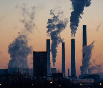
Aside from its effects on climate change, air pollution has also been identified as a major contributor to the development of respiratory diseases in humans. For this reason, even public health organizations across the globe have been working on using LiDAR to monitor the presence and severity of aerosol pollution in major cities and industrial areas.
While LiDAR cannot single out specific pollutants, it can measure the density of particulate matter in the air. Of particular concern to human health is particulate matter with a size of 10 nanometers or lower.
Particulate matter data collected by LiDAR can be mapped in any geographical area to determine where they are more concentrated. This can then be used to identify any significant sources of particulate matter pollution. The advantage of using airborne LiDAR systems is that they can collect large datasets over a huge area very quickly. This is essential in urban and industrial areas where frequent data collection is needed.
Autonomous vehicle navigation
Elon Musk once said that computers make better car drivers than people. While that can be dismissed as an attempt to sell more electric self-driven vehicles, we can all aspire for a future where our cars can do the driving for us. This may take a long time to happen but we’re pretty sure such cars will use a form of LiDAR technology.
LiDAR sensors have a lot of capabilities that make them ideal for such applications. They can do very quick scans allowing for rapid AI-aided decisions. They can work under minimal visibility. Since LiDAR systems are firmware-based, they can also be updated periodically with better intelligence.
Right now, several car companies developing self-driving technology are doing it on the foundation of LiDAR. Ironically, Tesla is the only company that does not use LiDAR, relying instead on a computer vision platform.
This conflict highlights the limitations of LiDAR. While LiDAR can pick out objects in the environment quickly, it cannot identify what those objects are. For LiDAR, a child crossing the street will be treated equally to a cardboard box blowing in the wind. For this idea to work, LiDAR needs to be integrated with some sort of object identification intelligence.
Traffic enforcement

In traffic enforcement, LiDAR is used for two primary functions. The first is as a means of detecting the speed of moving vehicles. Over the past years, LiDAR has largely replaced radar as the technology for this application. Compared to radar, the light pulses of LiDAR have a much narrower beam of convergence, making it possible for speed guns to more accurately target specific vehicles.
When a traffic violation happens, one of the first things that traffic enforcers do is to take note of the violator’s license plates. This task may not be as easy when there’s poor visibility. This is where LiDAR becomes useful again, as a quick scan can record the contours of a license plate.
Precedence to the use of LiDAR scans as legal evidence was set by a case back in 2008. However, there are still proper ways to use LiDAR scanners so that they do not produce false readings.
Gesture recognition
Gesture recognition has been a feature in many smartphones for about a decade now. The problem with this camera-based gesture recognition is that it was not perfectly reliable and often had a delay in response. Nowadays, LiDAR is being explored as the standard means for gesture control.
The value of accurate and responsive gesture recognition has many industries wanting to get in on this action. In commercial spaces, gesture control can make it possible to control customer kiosks in a manner that is truly contactless – quite important in a post-COVID world. A company called Insight LiDAR is developing a LiDAR module into self-driven cars that can analyze the movement of pedestrians in the environment.
Even the military is interested in this technology for their soldier-robot combat teams. Instead of having to operate a robot or drone using a handheld controller, the operator can just use hand signals just like they would with another human soldier. A LiDAR-based gesture control system has the advantage of speed and accuracy, as well as being operable during the night.
Documentation of archeological sites
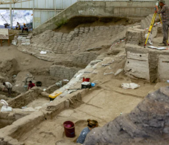
Quite surprisingly, LiDAR has proven to be a revolutionary technology in the practice of archaeology. A chief advantage of LiDAR is that it has the ability to penetrate through vegetation and survey structures that otherwise would not have been visible even to an airborne human observer. This has led to the discovery of several archaeological sites.
In 2010, a team of archaeologists published a paper on the discovery of an ancient Mayan site at Caracol in Belize. This area had been studied for 25 years prior to the discovery with great difficulty because of thick vegetation. With seemingly very little effort, a LiDAR survey generated a 3D model of an 80 square mile area which at that point had been surveyed very minimally.
In another case, airborne LiDAR was able to detect ancient Roman villas in Croatia. The difference here is that the site was already submerged underwater, making this scenario related to bathymetry. According to an anthropologist in the team, the LiDAR survey accomplished in 45 minutes the work that would take a decade using traditional means.
With the capabilities of LiDAR fully evident, there have been various initiatives around the world to model historical sites and state landmarks using laser-based surveys. This came in handy when the Notre Dame cathedral burned down two years ago.
Fortunately, a 3D model of the palace had already been generated through LiDAR scans. With that 3D model as a blueprint, rebuilding the Notre Dame cathedral to its old splendor as possible.
Final thoughts
For many people, the iPhone 12 Pro was their first exposure to LiDAR technology. However, it has been around for a few decades and is already being used across several industries.
Despite that, there is still a lot of room for LiDAR to be more extensively used. From meteorology to traffic enforcement, there are already several scenarios in which LiDAR technology has been used in unexpected ways. Will we see more smart cities, cars, and phones with LiDAR sensors soon? The signs seem to say that we’re headed in that direction.