What are Multispectral Drones and How Can You Use Them?

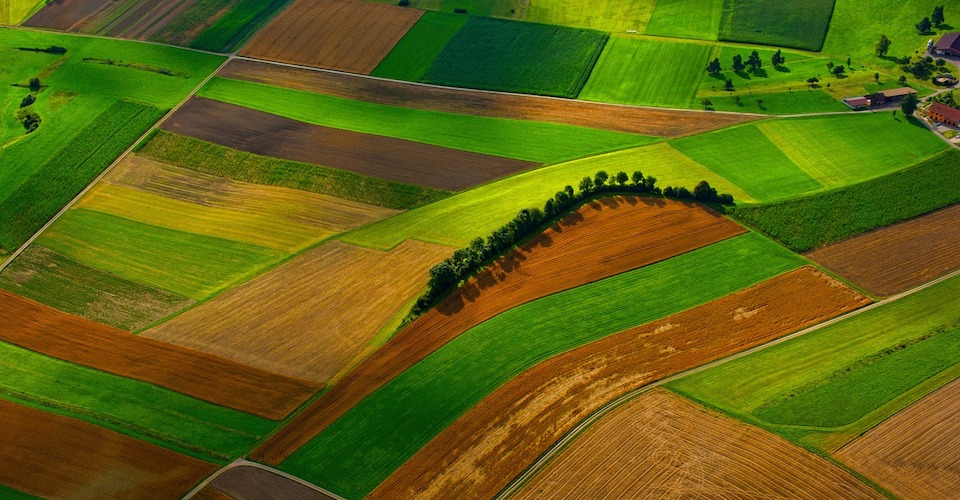
Far from their beginnings in the military, drones have started to enter the commercial and industrial world in a variety of ways. In recent years, drones have been used for photography, advertising, filmmaking, surveillance, search and rescue, construction, and infrastructure. The ability of drones to fly over large areas safely and quickly has been especially useful. Combining this with multispectral sensors has turned drones into very powerful tools for data collection and aerial imaging.
What is multispectral imaging and how does it work?
A multispectral image is captured by recording image data at different frequencies along the electromagnetic spectrum. These include frequency bands outside of the visible spectrum, which is limited only from 400 to 700 nm. This frequency (or accordingly, wavelength) range corresponds to the colors perceptible by humans – from violet to red.
Outside this frequency, energies can no longer be seen by the naked human eye. However, studies have shown that these “invisible” energies can be very useful in determining the characteristics of soil, crops, and plants.
The idea of analyzing multispectral images to assess crop and plant health is based on the concept of different surfaces having different rates of absorption and reflectance of particular bands of energy. For instance, the presence of the chlorophyll pigment in healthy plants lead to a higher rate of absorption of visible light. In contrast, unhealthy crops and bare soil surfaces absorb a lower amount of visible light. Near-infrared light shows a similar behavior, albeit with an inverse relationship – healthy crops absorb a smaller amount of near-infrared light.
Multispectral sensors are not limited to measuring only visible light and near-infrared energy. Throughout the years, multispectral sensors have become more and more sophisticated. They are now able to capture more discrete energy bands such as red-edge and thermal infrared. How these energy bands are interpreted and their value to farmers will be discussed in detail in a separate section below.
The benefits of multispectral imaging
Using drones for multispectral imaging has led to the development of a completely new discipline called precision agriculture. Precision agriculture relies on large amounts of temporal and spatial crop data to help farmers make data-driven decisions. Aside from the main goal of improving overall crop health, precision agriculture also increases efficiency by minimizing waste through targeted delivery of fertilizers, pesticides, and other supplies.
The use of multispectral imaging generates data and intelligence at a rate and level of accuracy that cannot be matched by traditional methods. Aside from the obvious advantage of drones being able to cover large areas much faster than surveyors, multispectral sensors can collect data which cannot be perceived by human senses. Combined with the ability to build databases of multiple multispectral images collected over time, the use of multispectral imaging for precision agriculture can provide valuable insight on crop management that otherwise would not have been available to farmers.
A concrete and common application of precision agriculture is in the design of variable-rate spreading techniques for fertilizers. With the use of multispectral imaging, farmers can easily identify areas in the field with poor crop health and adjust the amount of fertilizer for these areas accordingly. Conversely, fertilizer meant for very healthy areas can be reallocated to other areas. The goal of this practice is to reduce the overall usage of fertilizer, ultimately generating savings in farm operations.
The practice of using multispectral imaging as a tool for farm management has been adopted for a long time by developed countries such as United States, Canada, and Australia. In developing countries, the rate of adoption of precision agriculture has been lagging primarily due to the high initial costs of purchasing a drone with a multispectral sensor. Still, we are optimistic that the technology will get cheaper in the future as it becomes more mature and available to a wider audience.
Vegetation indices
Vegetation indices are used by the agriculture community to simplify interpretation of multispectral images. By combining measurements from two or more frequency bands, different values of vegetation indices can be associated with specific vegetation and soil characteristics. Vegetation indices also have the advantage of being limited within a very small range, frequently from -1 to +1. This greatly simplifies report generation and data interpretation.
Since the development of multispectral imaging, more than 150 vegetation indices have been formulated in various literature. However, only a small portion of this number has been systematically tested and are useful for most applications. The two most commonly used vegetation indices are the Normalized Difference Vegetation Index (NDVI) and the Normalized Difference Red Edge (NDRE). Each one of these common indices utilize different multispectral bands and can be used to deduce distinct crop characteristics.
1. Normalized Difference Vegetation Index (NDVI)
The NDVI is by far the most commonly used vegetation index and is commonly referred to as a measure of the “greenness” of crops. This index is based on the premise that plants with very active photosynthesis absorb most of the visible light and reflect most of the near-infrared light. Conversely, dead or stressed vegetation tend to reflect more visible light and absorb more near-infrared light. Non-vegetated surface, such as bare soil or bodies of water, display close to equal reflectance of both visible and near-infrared light.
For simplification, NDVI is calculated using the color red as representative of the visible spectrum. It is calculated for every single pixel of a multispectral image as the normalized difference between the intensity of reflected energy in the red and near-infrared bands. By taking the difference of values between two bands, the effect of extraneous factors such as image illumination are cancelled out.
In addition to providing an indirect measure of plant photosynthetic activity, NDVI values and maps can also be used to identify areas with frost damage, pest infestation, and carbon sequestration. It is a very versatile tool that can be used to assess levels of plant stress, soil moisture, biomass, and total plant cover.
Despite its ubiquity and usefulness, modern precision agriculture practices rarely use NDVI independently. It is commonly paired with RGB images as well as multispectral images made for other vegetation indices to provide more comprehensive crop analysis metrics.
2. Normalized Difference Red Edge (NDRE)
The NDRE index uses the red edge band instead of near-infrared to come up with a metric to analyze crop health based on multispectral images. In terms of the electromagnetic spectrum, the red edge region is a very narrow band between the visible red color and the near-infrared region.
The use of the red edge band differentiates the measured reflectance as a result of pure chlorophyll absorption (red edge) and scattering due to the leaf internal structure (near-infrared). As an indirect measure of chlorophyll levels, NDRE provides a metric for quantifying the levels of photosynthetic activity at various areas within a field.
More than being just a metric for crop health, information on photosynthetic activity allows farmers to harvest produce at the best possible times. For instance, drastic changes in NDRE values happen once almond hulls start to split or when fruits reach their maximum sugar content. The accumulation of sugar happens when the fruit or nut has reached maturity and thus no longer needs the sugar for growth and other metabolic processes.
Unexpected changes in NDRE can also be interpreted as a sign of pest infestation. The practice of NDRE monitoring allows farmers to step in early with pest control, avoiding further loss of crops due to pest outbreaks and saving on costs associated with the use of pesticides.
The NDVI and NDRE indices are two of the most common and most useful vegetation indices used in the whole precision agriculture industry. They are relatively simple to use and interpret but provide great value in crop management and improvement of harvest quality.
Multispectral bands used for vegetation
Armed with the knowledge of which vegetation indices would be best to measure, it is now time to identify the spectral bands needed to determine these indices. Most multispectral sensors can capture images at 2 to 3 bands, which is usually enough for most applications. Which bands are these exactly?
1. Green
One component of the visible spectrum that multispectral imaging uses, green is the color with the highest reflectance value out of all the visible colors. The peak of reflectance in this band is at around 550 nm, which strongly corresponds to a high amount of chlorophyll in vegetation. In simplest terms, capturing images in this band allows us to assess the “greenness” of a particular area in the field.
However, the color green in itself is not enough to measure the level of health of any patch of vegetation. To the naked eye, an unhealthy plant may appear almost as green as a healthy one. Subtle differences are more reliably distinguished by capturing images outside the band of visible light.
2. Red
The second component of visible light considered in multispectral imaging, red is also strongly absorbed by the chlorophyll pigment in plants. However, the reflectance of red exhibits slightly more variety as it is influenced by the presence of biomass, crop type, humidity levels, soil history, and degree of plant stress.
With its more discerning characteristic, red is the most commonly used visible color used in several vegetation indices.
3. Red Edge
The red edge is a very narrow band that sits right between visible red and near-infrared. This is a very interesting band as it exhibits a very sharp change in reflectance on surfaces with vegetation, with visible red being strongly absorbed and near-infrared being almost completely reflected. Thus, the red edge band is widely used as a very sensitive indicator of plant stress and the levels of chlorophyll in any vegetation.
4. Near-infrared
Relative to the visible spectrum and the red-edge band, the near-infrared band exhibits the strongest reflectance on vegetation. High levels of chlorophylls in plants has been strongly associated with a high reflectance of near-infrared energy. This reflectance is severely diminished when plants are under stress.
Near-infrared reflectance is also significantly affected by leaf cellular structure, making it a good indirect measure of good water management, optimal soil properties, and the effects of erosion on vegetation.
In combination with visible red, near-infrared is very commonly used in most vegetation indices. By contrasting the reflectance of near-infrared with the reflectance of visible light, more information can be deduced about a plant’s level of health and productivity.
5. Thermal infrared
Thermal infrared sensors are more specialized equipment that are designed to generate thermal maps. Instead of measuring reflected energy, thermal infrared sensors measure the latent infrared energy that all objects emit. Thermal vision cameras have been used in precision agriculture to detect areas with poor irrigation, soil stress due to high salinity, and plant diseases.
Thermal imaging is a technology that has been used in much more applications outside of agriculture. The ability to detect thermal signatures or “hot spots” is useful in identifying insulation leakages in homes and buildings, as well as in surveillance or search and rescue jobs.
6. RGB sensors
Put simply, RGB sensors are used by typical cameras for capturing of aerial images using the full spectrum of visible colors. Many multispectral sensors have integrated RGB sensors to provide visual farm inspection and surveillance capabilities on top of multispectral imaging. With some post-processing software algorithms, RGB sensors can be used to capture overlapping aerial images to generate digital elevation or topography models. Statistical tools can also be applied to aerial images to come up with a system of plant counting.
The best multispectral sensors
Instead of developing drones that are dedicated to multispectral imaging, many manufacturers have instead come up with their own modular and lightweight multispectral sensors. These can be attached to most enterprise-level drones, effectively augmenting their capabilities.
1. Parrot Sequoia
The Parrot Sequoia is one of the most versatile and capable multispectral sensors available today. It uses four highly defined spectral bands (Red, Green, Red Edge, and Near-infrared) in addition to a 16 MP RGB camera. The Parrot Sequoia can also be mounted on the back of a drone to make use of its Sunshine sensor, which records the light conditions using the same spectral bands and uses this data to calibrate the multispectral images.
The Parrot Sequoia comes with its own GPS receiver, inertial measuring unit (IMU) and magnetometer for accurate assignment of positional data to each pixel of the multispectral images. It has an internal storage capacity of 64 GB, which should be just enough for up to 10 flights. It is a surprisingly compact and lightweight device, making it an excellent attachment to a drone without compromising on flight performance.
The Sequoia is compatible with many popular survey drones such as the Phantom series from DJI and the SenseFly eBee fixed-wing drones. Parrot has also developed their own specially designed precision agriculture drones that come pre-equipped with the Sequoia multispectral sensor.
2. MicaSense RedEdge MX Sensor
The RedEdge MX is the latest multispectral sensor to come out of the popular MicaSense brand. Weighing in at only a little above 200 grams, the RedEdge MX is an incredible compact and lightweight piece of equipment. It can capture images at 5 spectral bands: blue, green, red, red edge, and near-infrared. It is equipped with a global shutter which ensures that all images are synchronized across all 5 bands.
The wide array of capabilities of the RedEdge MX will allow a farmer to quickly and easily generate NDVI maps, chlorophyll maps, digital elevation models, and high-quality RGB images. The kit also comes with a dedicated light sensor, the DLS2, which is placed on top of the drone for sunlight calibration. It comes with an external SD card slot and a removable Wi-Fi module for additional storage and connectivity options.
MicaSense has a small selection of integration kits to aid in the installation of the RedEdge MX with some popular enterprise-level drones. Currently, the RedEdge MX can only be used with the DJI Inspire 1 and 2, and the DJI Matrice 100 and 600. You can choose to either have a quick mount kit that allows you to remove and attach the RedEdge MX instantly, or a fixed mount kit that offers more stability and permanence.
3. Sentera Quad Multispectral Sensor
The Sentera brand offers a selection of multispectral sensors that support a different number of spectral bands. We are partial to the Sentera Quad Multispectral Sensor which features four fully-customizable multispectral imagers. With this capability, you can capture maps that suit your specific needs. Whether you want to generate an NDVI map, NDRE map, or a high-resolution aerial image, the Quad Multispectral Sensor can perform exceptionally well. A global shutter ensures synchronized image collection between all of the spectral bands.
The Sentera Quad Multispectral Sensor has a 32 GB SD card slot provision for each sensor, allowing for storage of up to 200,000 JPG images on each card. The sensor is a little bigger than most, so it’s best installed on DJI Inspire 1 or 2. Better yet, the Quad Multispectral Sensor is the perfect fit for Sentera’s very own PHX fixed-wing drone. Sentera also offers installation of this sensor to the DJI Phantom and 3DRobotics Solo drones.
The best drones for multispectral imaging
If you want to get into precision agriculture, your best bet is to get a drone that was specifically designed for multispectral imaging. These enterprise-level drones offer GPS guidance for mission planning, better flight stability, and longer flight times. You can also choose to get a professional-grade drone and augment it with any of the after-market multispectral sensors we have listed above.
1. DJI Smarter Farming Package
The DJI Smarter Farming Package is probably the most complete bundle that anyone could get for precision agriculture. Aside from the very reliable DJI Matrice 100 drone and the dual visual and multispectral sensors, this package also comes with a rugged carrying case, extra batteries, and subscription to software for mission planning and data post-processing. The whole setup arrives fully assembled and ready-to-fly, so you can have your drone up in the air in no time.
The DataMapper Standard data processing software has a library of 11 different crop analytical tools and can generate all the usual maps such as NDVI, Enhanced NDVI, and Difference Vegetation Index among others. With its ever-growing library, this subscription will keep you at the forefront of the evolving field of precision agriculture.
2. Parrot Bluegrass Fields
The Bluegrass Fields is Parrot’s quadcopter designed specifically to work with their own Sequoia multispectral sensor. The Bluegrass Fields also has a front-facing RGB camera to add high-resolution imagery to the Sequoia’s multispectral imaging capabilities. The front-facing camera can capture 14MP stills and record video at 1080p resolution.
The Parrot Bluegrass Fields comes bundled with the ParrotFields mobile app. This app is a valuable tool for quick survey planning and execution and even provides real-time NDVI map generation. This allows you to step in at any point of the survey to revise the mission goals or to focus more on problem areas. Through the mobile app, you can add annotations to survey data and geotag photos taken by the drone’s front-facing camera
3. Parrot Disco-Pro Ag
The Parrot Disco-Pro is the fixed-wing counterpart of the Bluegrass Fields. It has much of the same multispectral imaging capabilities as provided by the built-in Parrot Sequoia sensor. However, it’s fixed-wing design allows the Disco-Pro Ag to fly nearly 4 times longer than the Bluegrass Fields. The Parrot Disco-Pro Ag is an excellent solution for conducting precision agriculture surveys in very large tracts of land.
Contrary to popular opinion, flying a fixed-wing drone like to the Disco-Pro Ag is not difficult at all. It can be hand-launched and has an automatic landing function. It does not offer the same level of maneuverability as quadcopters, and has no hover function, but makes up for it with longer flight times and much faster speeds.
The Disco-Pro Ag bundle comes with the Airinov First, a cloud-based crop analysis platform that allows for almost instantaneous generation of NDVI maps as soon as the survey crop data has been synced with its server. The software is also capable of generating prescriptive actions on crop management based on the results of crop data post-processing.
4. DJI Phantom 4 Pro
You do not need to restrict yourself to dedicated agriculture drones to perform multispectral imaging. An excellent enterprise-level drone such as the DJI Phantom 4 Pro can perform the same job after a few modifications. The Phantom 4 Pro is compatible with Parrot Sequoia and Sentera multispectral sensors. You can choose to either have the sensors mounted on the drone by professional services or buy the mounting kits and do it yourself.
The DJI Phantom 4 Pro is one of the most reliable and widely used professional drones, thanks in no small part to its superior flight stability and 30-minute maximum flight time. It has been used across different commercial applications but is remarkably easy to fly.
5. Yuneec Typhoon H Plus
Another excellent choice for a professional-grade drone that can be used with after-market multispectral sensors is the Typhoon H Plus from Yuneec. This drone is primarily used for aerial photography but is also compatible with the Parrot Sequoia multispectral sensor. True to the Typhoon brand, the Typhoon H Plus retains the signature hexacopter design. With a redundant rotor, the Typhoon H Plus is probably one of the safest drones you can fly.
The increased stability offered by the hexacopter design makes the Typhoon H Plus an exceptionally good choice for multispectral imaging surveys. Aided by the Intel RealSense collision avoidance technology, the Typhoon H Plus is exceptionally easy to fly. With the ability to withstand winds of up to 35 mph, a range of up to 1 mile, and a camera that can capture videos in 4K resolution, the Typhoon H Plus is an extremely powerful and versatile drone that can serve many commercial needs.
Final thoughts
Multispectral imaging is one of the more advanced and specialized applications of drone technology. It may also be one of the most useful and socially relevant, especially in today’s world where world hunger and food scarcity are two of the most pressing issues.
Multispectral imaging pushes the boundaries of sensor and drone technology to aid in crop management, making farms more profitable and efficient. The ability to capture huge amounts of data on crop health quickly and with little effort allows farmers to step in on problem areas immediately, resulting in less crop waste and better harvest quality.
The market for multispectral sensors is still quite small, and there are only a few brands that manufacture these sensors. They are also expensive, at least costing upwards of $5000. We are optimistic that this technology will continue to mature in the next few years, ultimately making it more accessible in terms of cost and availability.