A Free Study Guide for the Part 107 Knowledge Test

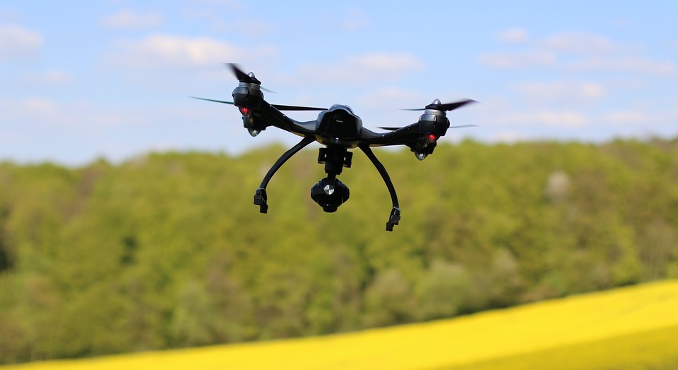
The process of getting a Part 107 drone license is not exactly complicated. You just have to satisfy the basic requirements, sign up for the knowledge test, pay a fee, pass the test, and claim your very own drone license. The main hurdle in getting one is, of course, passing the knowledge test. The Part 107 knowledge test requires substantial knowledge on topic such as drone aerodynamics, weather, air space classifications, communication standards, emergency procedures, and drone checkups and maintenance. The point is that you will have to commit significant time and effort to prepare for the test.
There are dozens of resources available online that you can use to help your prepare for the knowledge test. To contribute to this effort, we have compiled below a list of the topics, facts, and figures into a comprehensive and easy to understand study guide. If you can retain 100% of the knowledge listed here, then you have a great chance of passing the Part 107 knowledge test.
Quick Facts
- You can only legally fly a drone that weights less than 55 pounds.
- A drone that weighs less than 0.55 pounds does not need to be registered.
- The fastest speed you can fly your drone is only 100 mph or 87 knots.
- The maximum altitude you can fly your drone is only 400 feet.
- You can fly above 400 feet only if you are within 400 feet of a structure.
- You can only fly 1 drone at a time.
- You can only fly your drone during daytime, or at twilight (30 minutes before sunrise or sunset) with appropriate anti-collision lights.
- Your anti-collision lights must be visible from within 3 statute miles when flying during twilight.
- You must maintain a minimum visibility of 3 statute miles at all times during flight.
- The remote pilot certification is only valid for 2 4 months.
- The maximum blood alcohol level with which you can fly a drone is 0.04.
- 8 hours must have passed after consuming alcohol before you can fly a drone.
- In case of an accident, you must file a report to the FAA within 10 days.
- An accident refers to any event that caused personal injury (AIS Level 3) or at least $500 worth of property damage.
- Should you change your address, you need to notify the FAA within 30 days.
- If you are requesting a waiver from the FAA, you must consider a lead time of 90 days.
Airspace Classification
There are four airspace types: controlled, uncontrolled, special use, and other use. The classification of airspace is determined by the density and complexity of aircraft movement, the nature of the operations conducted in the airspace, the level of safety needed, and national and public interest.
Controlled airspace refers to the airspace in which air traffic control (ATC) authority is provided according to the airspace classification. A remote pilot needs to have knowledge on 4 controlled airspace classifications: Class B, C, D, and E.
Class B Airspace – The most restricted airspace, this classification covers altitudes from the surface to 10,000 feet mean sea level (MSL) in the periphery of busy airports with a high number of airport operations and passenger enplanements. The configuration of Class B airspace is individually tailored to each airport, but is always arranged in layers resembling an upside-down wedding cake. ATC authorization is needed to conduct drone flight operations in Class B airspace.
Class C Airspace – This is airspace covering the surface to 4000 feet above the elevation of an airport that has a control tower, is serviced by a radar approach control, and has a certain number of instrument flight rules (IFR) operations or passenger traffic. The configuration of this airspace is also tailored according to the concerned facility, but usually has a 5 NM (nautical mile) radius from the surface to 4000 feet, and a 10 NM radius from 1200 to 4000 feet. A remote pilot must also secure ATC authorization to conduct operations in Class C airspace.

Class E Airspace – Controlled airspace that is not classified as Class A, B, C, or D is classified as Class E airspace. In most areas, Class E airspace begins at 1200 feet above ground level (AGL) up to 18000 feet MSL, which is the lower limit of Class A airspace. Usually, an ATC authorization will not be needed for a remote pilot to fly in Class E airspace
Uncontrolled airspace or Class G Airspace refers to the portion of the airspace that does not belong to the A, B, C, D, or E classes. It covers the surface up to the base of the overlying Class E airspace. An ATC authorization will not be needed for a remote pilot to fly in Class G airspace.
Special Use Airspace or special area of operation (SAO) refers to airspace where limitations are implemented on aircraft operations due to the nature of activities being conducted therein. These activities could include military operations, flight tests or exercises. An airspace could also be classified under this category due to national security issues or if it does not fall under the sole jurisdiction of the USA.
Prohibited areas (P-####) are airspace in which aircraft flight is prohibited due to security issues or in the interest of national welfare. Examples of prohibited areas are the White House and the Congressional buildings. These areas are listed under the Federal Register, and indicated in aeronautical charts as a “P” followed by a number (for example, the area surrounding Camp David is listed as “P-40”).
Restricted areas (R-####) are airspace in which aircraft flight is not necessarily prohibited, but can be dangerous. Activities conducted in these areas, such as testing of artillery and guided missiles, are commonly hazardous to non-participating aircraft. If the restricted area is active and has not been released to the FAA, clearance will have to be secured from the ATC prior to conducting remote flight operations. In charts, restricted areas are marked with an “R” followed by a number (e.g. R-4401).
Warning areas (W-####) are similar to restricted areas in that they contain activities that can be hazardous to the aircraft. However, warning areas do not fall under the sole jurisdiction of the USA. As such, a warning area can be located above domestic or international waters. Flying in warning areas is not necessarily prohibited but caution is recommended. Warning areas are indicated in charts with a “W” followed by a number (e.g. W-327).
Military Operation Areas (MOA), as the name implies, refer to the airspace where certain military training activities are conducted. In most cases, ATC reroutes or restricts non-participating traffic from a MOA. MOAs are depicted on charts, and are not numbered. However, they often consist of multiple Restricted Areas, such as the Chocolate Mountain Impact Area (R-2507) and Chocolate Mountain Aerial Gunnery Range (R-2507).
Alert Areas (A-####) are areas that contain a high volume of pilot training or other unusual types of aerial activity. Non-participating pilots are advised to exercise caution in these areas. Both participating and non-participating pilots are held equally responsible for collision avoidance. Alert Areas are indicated by “A” followed by a number (e.g. A-211) in charts.
Controlled Firing Areas (CFAs) are controlled environments where activities are conducted which may be hazardous to non-participating aircraft. The difference with CFAs and other special use airspace is that the activities being conducted in a CFA will be suspended if an incoming aircraft is detected. CFAs are not indicated in charts since they do not require non-participating aircraft to reroute.
Other airspace areas refer to the majority of remaining airspace that is not yet classified into the previous categories. These include:
Local Airport Advisory (LAA) – An advisory service provided by the Flight Service facilities of a landing airport, which include automated weather reporting, local airport advisories, data from the Automated Surface Observing System (ASOS) and the Automated Weather Observation Station (AWOS), and other continuous reading instruments.
Military Training Routes (MTRs) – These are used by the military for tactical flight training, and are usually established at altitudes below 10,000 feet. Military aircraft operating across these routes commonly fly at speeds in excess of 250 knots. MTRs are identified in charts as IR-### and VR-###.
Temporary Flight Restrictions (TFRs) – These are issued by a flight data center (FDC) as Notice to Airmen (NOTAM) in extraordinary situations, such as for the protection of the President or other state figures, or to provide a safe airspace for the operation of disaster relief aircrafts. Temporary flight hazards such as airshows, kite flying events, or the passing of a flock of birds, may be grounds to issue a NOTAM. The NOTAM states the location of the temporary restriction, the effective time period, the extent of the area in statute miles, the included altitudes, and the reason for the restriction. It is the responsibility of a pilot to check for NOTAMs during flight planning.
Parachute Jump Aircraft Operations – Frequently used parachute jump airspace are published and depicted on sectional charts.
National Security Areas (NSA) – These are airspace that are over locations where increased security and safety of the ground facilities has been implemented. Flight over NSAs may be temporarily restricted by regulation, and these prohibitions will be distributed via NOTAM. Flight etiquette dictates that pilots are expected to voluntarily avoid flying over NSAs.
Reading Aeronautical Charts
Remote pilots need to be familiar with some of the terms and symbols used in aeronautical charts. Below is a quick guide to the most important VFR (Visual Flight Rules) terms and symbols.
| Feature | Symbol | Description |
| Water features (hydrography) | 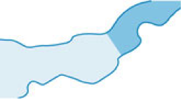 | Water features are considered either “Open Water” (lighter blue) or “Inland Water” (darker blue). Open Water includes all coastal water features and connecting water features such as bays and gulfs. Exceptionally large lakes are also considered Open Water. |
| Terrain (contour lines) | 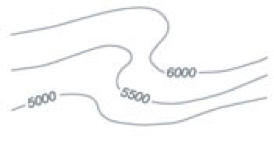 | Contour lines connect points of equal elevation. The graduations of the contours may vary, but intervals of 50 feet to 250 feet are common. |
| Terrain (shaded relief) |  | Shaded relief maps are another way of visually representing the terrain of an area. Shadows in a relief map are shown as if there is a light source in the north-west. |
| Man-made obstacles below 1000’ AGL |  | The FAA maintains a database of man-made vertical features that can affect safe air navigation. Each obstacle is evaluated before it is added to aeronautical charts. |
| Man-made obstacles above 1000’ AGL |  | |
| Group obstacle |  | When obstructions cannot be identified individually, such as in high-density city centers, only the highest obstacle is represented on the chart using the Group obstacle symbol. |
| Obstacle under construction |  | If the position or elevation of an obstacle cannot be accurately determined or is not yet verified, it is marked UC or ‘under construction’. |
| Checkpoint | 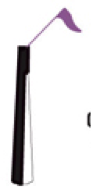 | When a man-made feature is being used as a checkpoint by the FAA, it is denoted as symbol in black and white. |
| Lighted obstacles |  | Obstacles with high-intensity and strobing lights are indicated by special symbols. |
| Maximum elevation figure (MEF) |  | The MEF represents the highest elevation, including terrain and man-made features, in a quadrant. A quadrant is defined as an area bounded within 30 minutes latitude and 30 minutes longitude. MEF numbers are rounded up the nearest hundred, with the last two digits omitted. (In this example, the figure refers to 12500’ elevation) |
| Public use airports |  | Airport with hard-surfaced runway greater than 8069’, or with multiple runways less than 8069’ |
| Airport with hard-surfaced runway between 1500’ and 8069’ | ||
| Airport that does not have a hard-surfaced runway | ||
| Seaplane base | ||
| Military airports *Identified with abbreviations such as AAS (Army Air Field) or MCAS (Marine Corp Air Station) | | Military airport with hard-surfaced runway (same symbol as public airport) |
| Military airport that does not have a hard-surfaced runway | ||
| Fuel availability |  | Tick marks around the standard airport symbols means that fuel is available in the airport Monday through Friday at 10AM to 4PM. |
| FAR93 Airports |  | Airports under the Federal Aviation Regulation 93 (FAR93) are depicted with ‘boxed’ airport names. |
Aviation and Weather
Aviation weather services are provided by a collaborative effort of the government and private facilities. Up-to-date weather information is collected by automated weather sources, such as the Automated Weather Observing System (AWOS), the Automates Surface Observation System (ASOS), and other automated facilities. These surface observations are delivered by particular airports, and are very valuable information for remote pilots. The information contained in these reports include the station identified, the type of report, date and time, wind, visibility, runway visual range (RVR), weather phenomena, temperature or dew point, sky condition, altimeter reading, and other remarks.
Aviation Weather Reports are designed to give accurate but concise descriptions of current weather conditions. Typical weather reports are in the format of either METAR or PIREP.
Aviation Routine Weather Report (METAR) – A METAR is a report on current weather conditions in a standard international format. METARs are delivered according to a regular schedule unless there are significant and exceptional weather changes. A special METAR report is called a SPECI, and can be issued between routine METAR transmissions.
A standard METAR report looks like this:
METAR KGGG 161753Z AUTO 14021G26KT 3/4SM +TSRA BR BKN008 OVC012CB 18/17 A2970 RMK PRESFR
To attempt to understand the METAR report, we must break it down into individual components.
- Type of report – This can either be the standard report (METAR) or a special report (SPECI) that is transmitted in cases of extreme weather changes, or aircraft mishaps.
- Station identifier – Denoted by a four-letter code as assigned by the International Civil Aviation Organization (ICAO), station identifiers refer to the monitoring stations that is issuing the report. Stations identifiers and their corresponding airports can be searched in various websites such as the DUATS and NOAA.
- Date and time of report – This is denoted by a six-digit group, of which the first two refer to the data, and the last four are the time of report transmittal (161753Z in our example). A “Z” is commonly added at the end of the string to indicate that the time is given in Zulu time instead of local time.
- Modifier – This term states “AUTO” is the report was generated from an automated source. On the converse, it will state “CORR” if the report was corrected and sent out to replace an earlier report that had an error.
- Wind – The wind direction and speed is reported in 5 digits unless the speed is greater than 99 knots, in which case it is reported in 6 digits (14021G26KT in our example). The first 3 digits indicate the direction from which the wind is blowing, represented in tens of degrees. If the wind direction is varying, then it is reported as “VRB”. The last 2 or 3 digits represent the wind speed in knots. If the winds are gusting, the letter “G” follows the wind speed, which is again followed by the recorded peak wind gust speed.
- Visibility – The prevailing visibility is reported in statute miles or a fraction thereof (3/4SM in our example). In certain situations, the runway visual range (RVR) is reported along with the visibility. RVR refers to the distance that a pilot can see down the runway from a moving aircraft. When RVR is included, it is prefixed by an “R” which is followed by the runway number and the visual range in feet (for example, R17L/1000FT).
- Weather – The weather term (+TSRA BR) can be sub-divided into individual terms that refer to different properties of the prevailing weather condition. The first variable refers to the intensity or proximity, indicated as light (-), moderate ( ), or heavy (+). The “VC” descriptor can also be used to describe the phenomenon as happening in the vicinity of 5 to 10 miles from the airport. Descriptors are then appended to describe particular precipitation or obscuration phenomena. The codes and their meanings are listed below.
| Qualifier | |||||
| Intensity / Proximity | Descriptor | ||||
| (-) | Light | MI | Shallow | ||
| ( ) | Moderate | BC | Patches | ||
| (+) | Heavy | DR | Low drifting | ||
| VC | In the vicinity | BL | Blowing | ||
| SH | Showers | ||||
| TS | Thunderstorms | ||||
| FZ | Freezing | ||||
| PR | Partial | ||||
| Weather Phenomena | |||||
| Precipitation | Obscuration | Other | |||
| DZ | Drizzle | BR | Mist | PO | Dust/sand whirls |
| RA | Rain | FG | Fog | SQ | Squalls |
| SN | Snow | FU | Smoke | FC | Funnel cloud |
| SG | Snow grains | DU | Dust | +FC | Tornado or watersprout |
| IC | Ice crystals | SA | Sand | SS | Sandstorm |
| PL | Ice pellets | HZ | Haze | DS | Dust storm |
| GR | Hail | PY | Spray | ||
| GS | Small hail or pellets | VA | Volcanic ash | ||
| UP | Unknown precipitation | ||||
- Sky condition – This denotes the amount, the altitude, and the vertical visibility (BKN008 OVC012B in our example). The first term refers to the amount of sky coverage reported in eights of the sky from horizon to horizon, as summarized below.
| Sky cover | Contraction |
| Less than 1/8 (Clear) | SKC, CLR, FEW |
| 1/8 – 2/8 (Few) | FEW |
| 3/8 – 4/8 (Scattered) | SCT |
| 5/8 – 7/8 (Broken) | BKN |
| 8/8 (Overcast) | OVC |
The altitude of the cloud bases are then reported with a 3-digit number in hundreds of feet AGL. The types of clouds are also recorded with their height. Examples of cloud types are cumulonimbus (CB) or towering cumulus (TC).
- Temperature and dew point – The air temperature and dew point is always reported in degrees Celsius. Temperature below 0 °C is reported with an “M” to indicate minus or negative values.
- Altimeter setting – This is always preceded by a letter “A” and reported as inches of mercury (inHg) in four digits. Rising or falling pressure can be reported in the remarks section as PRESRR or PRESFR, respectively.
- Zulu time – The standard time used in aviation, which implements a single time standard anywhere in the world.
- Remarks – The remarks section is optional, but is always preceded by the letters “RMK”. This section may contain information such as wind and visibility data, beginning and ending times of a particular phenomenon, pressure information, or any other information deemed critical by the reporting station.
Aviation Forecasts are generated using observed weather conditions, and are very helpful for pilots in their preflight planning. Remote pilots mostly need to be familiar with the terminal aerodrome forecast (TAF), although other forecasts are also available such as the aviation area forecast (FA), and the Airman’s Meteorological Information (AIRMET).
Terminal Aerodrome Forecast (TAF) is a report transmitted by large airports concerning the five statute mile radius around them, and are valid for 24 or 30-hour time periods. The TAF is updated four times a day: 0000Z, 0600Z, 1200Z, and 1800Z. The TAF report looks very similar to the METAR, and uses much of the same contractions and definitions. A TAF report contains the following:
- Type of report – A report can either be a routine forecast (TAF) or an amended or revised forecast (TAF AMD).
- ICAO station identified – The identifier codes used in TAF are the same as those used in METAR.
- Date and time of origin – The code for time and date in TAF is the same as that used in METAR, with the first 2 digits referring to the date and the last 4 digits to the time. Time is always reported in UTC as indicated by the “Z” suffix.
- Valid period dates and times – The validity period of the TAF is reported with the first 2 digits indicating the date, and the last 2 digits indicating the time. For example, a validity of 0900/0924 means that the report is valid for 24 hours starting 0000Z of the 9th day of the month. TAF reports can be valid for 24 or 30 hour time periods.
- Forecast wind – The forecasted wind is reported in manner similar to that used in METAR. The first 3 digits indicate the wind directions expressed in degrees relative to the north, while the last two digits indicate the wind speed in knots appended with “KT”. Again, wind speeds in excess of 99 knots are reported using 3 digits.
- Forecast visibility – Visibility forecast is expressed in statute miles or a fraction thereof.
- Forecast significant weather – Weather phenomena are reported in the TAF using the same codes used in METAR.
- Forecast sky condition – Sky conditions are reported in the TAF using the same codes used in METAR.
- Forecast change group – This is indicated when there are sudden weather changes expected during the period when the TAF is valid. The information may be expressed as from (FM) and temporary (TEMPO). Temporary changes in weather are expected to persist for less than an hour.
- PROB30 – This is a percentage given to report the probability of thunderstorms and precipitation occurring in the next several hours.
Convective Significant Meteorological Information (WST) is issued when there is forecasted severe thunderstorms, hailstorms, tornadoes, or heavy precipitation.
The Effects of Weather on Drone Performance
In assessing how weather conditions affect the performance of your drone, it is enough to remember the simple relationship below:
Increase in air density = Lower density altitude = Increased aircraft performance
Decrease in air density = Higher density altitude = Decreased aircraft performance
Using this set of relationships, it will be easy to determine how prevailing weather properties such as pressure, temperature, and humidity will affect the performance of your drone. However, in assessing how a single component affects the outcome, it is important to keep all things constant. That is, in determining how changes in pressure affect drone performance, it is important that these results can be assumed only if temperature and humidity are held constant.
Pressure refers to the compressive force that acts on all molecules, such as the molecules of gases in the air. An increase in compressive forces means that air molecules become more highly packed, and air density increases. Thus, it can be concluded that an increase in pressure, in the absence of temperature and humidity fluctuations, results to increased aircraft performance.
Temperature also increases the density of gas molecules in the air. An increase in temperature provides more kinetic energy to molecules, thereby allowing them to move more rapidly, the air to expand further, and air density to decrease. Without changes in pressure and humidity, an increase in temperature results to a decrease in the overall drone performance.
Humidity refers to the amount of moisture in the air. Water vapor is actually lighter than air, and air with high moisture tends to decrease in density. Thus, high humidity leads to a decrease in drone performance. Humidity can also be expressed as relative humidity, denoted as a percentage of the maximum water vapor that air can hold in the prevailing temperature and pressure.
Dew point is a concept that relates to both temperature and relative humidity. It is the temperature at which the air can hold no more moisture, or is completely saturated with water vapor (100% relative humidity). At the dew point temperature, air starts to form dew, fog, clouds, or rain.
Altitude is another factor that affects air density outside of meteorological conditions. Air molecules are generally further apart in higher altitudes, meaning air density is lower. Low density air as the altitude increases negatively affects drone performance.
Wind shears are sudden changes in wind speed or direction which can subject an aircraft to violent updrafts or downdrafts. Wind shears can affect flight at any altitude. Drone pilots have to be wary of wind shears, as they can subject the drone to unexpected and sudden changes in movement, and severely reduce its performance.
Proper Drone Loading
Loading refers to the gross weight of the drone, including the weight of the drone itself, its accessories, and any payload that the drone is carrying. A remote pilot must always ensure that the drone is loaded properly In terms of both weight and balance prior to flight. Theoretically, a drone may be loaded with its maximum gross weight capacity, but atmospheric conditions may prevent this drone from taking off. Moreover, a heavily loaded drone displays poor movement, maneuverability, and vertical speed.
The ability to negotiate turns with your drone is also heavily affected by drone loading. During a coordinated turn, a drone’s load factor is a combination of both the centrifugal force and the force of gravity due to its weight. This load factor varies with the bank angle of the turn, as illustrated in the graph below.
It can be observed that the load factor on an aircraft increases dramatically past a bank angle of 60°, and approaches impossibility at 90°. The increased load factor presents an overload hazard on the aircraft’s structure, and renders the aircraft prone to stalling. A stall, or sudden loss of lift due to abrupt changes in flight characteristics, is something that remote pilots need to be wary of.
Emergency Procedures
Emergencies are unforeseen events that may have serious consequences. A remote pilot is allowed to deviate from the regulations of Part 107 to respond to an emergency, or to mitigate the hazards caused by an emergency. Upon the request of the FAA, a remote pilot may need to report the details of the emergency.
Radio Communication Standards
Radio communications allows remote pilots to receive critical information before, during, or after drone flight. This information may include flight restrictions, flight mishaps, airport advisories, weather forecasts, weather information, or any number of unexpected events. Remote pilots are generally not expected to communication via radio, but are expected to understand standard “radio language” to aid their situational awareness. One of the first things a remote pilot needs to be familiar with is the standard International Civil Aviation Organization (ICAO) phonetic alphabet. (Alpha, Bravo, Charlie…and so on).
Physiological Factors Affecting Pilot Performance
Under Part 107, a remote pilot is not allowed to operate a drone if he or she is not physically or mentally fit to carry out the responsibilities of the role. The conditions in which a pilot is deemed unfit to operate include:
- Having consumed any alcoholic beverage within 8 hours prior to flight
- Being under the influence of alcohol
- Having a blood alcohol content of 0.04 percent or higher
- Currently using a drug that impairs a person’s physical or mental capabilities.
In addition to these conditions, a person may have existing physical handicaps that will render him or her unable to perform the duties of a remote pilot properly. These physical conditions include:
- Hyperventilation – Loss of carbon dioxide from the blood due to abnormal breathing patterns. This can cause visual impairment, lightheadedness, or unconsciousness.
- Stress – Being under extreme physical or psychological duress. This can lead to increased heart rate, respiration rate, and blood sugar. Pilot performance falls off dramatically when under acute or chronic stress.
- Fatigue – Prolonged performance of cognitive work, which commonly lead to lack of focus, low attentiveness, and generally reduced pilot performance.
- Dehydration – The critical loss of water from the body. This can lead to headaches, cramps, fatigue, dizziness, and sleepiness.
- Heatstroke – This condition is caused by exposure of the body to extreme temperatures for prolonged periods, rendering the body unable to regulate its internal temperature. Symptoms of heatstroke may seem similar to dehydration, but can ultimately result in loss of consciousness.
- Drugs – Part 107 does not specify which drugs are prohibited for intake prior to drone flight. The regulations only state that a person is prohibited from acting as a remote pilot if he or she has taken drugs that will render him or her incapable of performing the duties and responsibilities of a remote pilot. These may include drugs that have adverse side effects, such as drowsiness and cognitive deficits. The regulations require that a drone pilot perform a self-assessment prior to any flight activity to ensure safety.
- Alcohol – Drinking alcohol has been proven to impair senses and render a person prone to poor judgment. Thus, Part 107 prohibits a person who has ingested alcohol in the past 8 hours, or has a blood alcohol content above or equal to 0.04 percent, from acting as a remote pilot.
Decision-Making and Judgment
Aeronautical Decision Making (ADM) is a systematic approach used in the aviation industry used to assess risks and determine the best course of action in any situation. The concept of risk management is one of the core principles of ADM. Through risk management, a pilot is able to identify hazards, assess the risks, develop measures to control the risks, implement actions, and monitor its results.
One of the common hazards in drone flight comes from the attitude of the pilot. These hazardous attitudes contribute to poor judgment and high-risk decisions. The 5 hazardous attitudes are:
- Anti-authority – Detesting being told what to do by authorities or disregarding rules and regulations
- Impulsivity – Jumping into decisions without proper and thoughtful deliberation of the consequences
- Invulnerability – Believing that accidents will not happen to them
- Machismo – Feeling the need to prove themselves by taking risks and trying to impress others
- Resignation – Feeling of helplessness, or always delegating necessary action to others.
Recognizing these 5 hazardous attitudes is the first step to trying to avoid them during the course of flight.
The PAVE Checklist (Pilot, Aircraft, Environment, External Pressures) is a decision-making aid that divides the risks of flight into four categories. With this tool, pilots have an easy-to-remember list that they can mentally run through before they fly.
P = Pilot-in-command
“Am I ready to fly?” – Experience, recency, physical and mental condition
A = Aircraft
“Is this the right aircraft? Is this an aircraft I am familiar with? Can this aircraft carry the planned load?”
V = EnVironment
“Are there any thunderstorms? What is the current ceiling and visibility? What is the weather forecast for the next couple of hours? Is there a temporary flight restriction?”
E = External Pressures
“Am I being pressured to perform? Do I feel the need to impress the people around me? Can I stick to standard, risk-averse flight?”
Keep in mind that human factors have been identified as the primary cause for more than 70 percent of aircraft accidents. By sticking to standard procedures and maintaining a risk-free attitude, the chances of accidents occurring will be reduced by great margin.