Drones for PPK Mapping Surveys – Detailed Guide

Aerial mapping has to be one of the best applications of drone technology. Drones are just uniquely suited for this. They are easy to use, can fly over large distances, fast, and versatile. With the ability to add accessories and components to drones, they have become useful tools across several different mapping applications.
However, mapping is a craft that does require a serious amount of expertise. Beyond basic GPS-based photogrammetry, there are much more complex processes and technologies that can be used to upgrade your professional mapping capabilities. In this article, we take a detailed look at PPK technology. What is it, and why is it considered superior to other mapping methods? How can I use PPK in my survey operations?
If you are doing drone mapping for commercial purposes, you need a Part 107 license from the FAA.

PART 107 Made Easy
- 161 Question and Answer Study Guide
- 105 pages of illustrated content
- Covers all parts of the Part 107 test
- $97 of value for free
A brief history of drone-based mapping
The idea of creating maps using aerial photography is decades old. Nowadays, this practice has developed into a whole field of study and is considered one of the more important facets of remote sensing. With drone technology, aerial mapping can be done even without using expensive and complex manned aircraft or helicopters.
The most basic aerial mapping technique uses the process of photogrammetry. This is simply a process by which several overlapping photos are stitched together by a software algorithm. The software doesn’t just simply “stitch” the photos, though. My matching features in the photos pixel by pixel, the horizon, and vertical measurements of the features can be determined. The result is a location-accurate 3D model that is fully navigable.
Just about any drone with a good camera and an onboard GPS module can be used for photogrammetry. By “geotagging” each photo – or associating it with a point along a geodetic reference system – each feature can be matched to its counterpart in the other photos.
The problem with this basic method is that GPS has limitations in terms of accuracy. The GPS modules in drones work by receiving signals from GPS satellites in the Earth’s orbit. The location of the drone is then determined by a triangulation method. Most times, you can expect to a location reading with a margin of error of at least 10 meters. For some industrial applications, error at this magnitude is simply unacceptable.
What is PPK?
One technological solution to addressing the accuracy limitations of standards GPS is to use a Post-Processing Kinematic (PPK) system. If you’ve read our piece on drones that use Real-Time Kinematic (RTK), then a PPK setup should sound very familiar to you.
In a PPK mapping setup, a ground station collects location data at the same time as a PPK or RTK module mounted on the drone. Since the location of the ground station is determined much more accurately, any measurements made by the module mounted to the drone is corrected according to the ground station measurements. A PPK upgrade results in a massive improvement to accuracy compared to GPS. Both RTK and PPK methods have been often touted to produce centimeter-level accuracy.
What’s the difference between PPK and RTK?
Both PPK and RTK seem to use the same equipment, so how are they different and which one is better? The key to understanding the difference between PPK and RTK is knowing that they use virtually the same technology. However, they use different workflows to achieve the same goal.
In RTK, measurements corrections are made “real-time,” as its name implies. This requires the ground station and the onboard RTK module to be in constant communication throughout the survey. However, this may be difficult to achieve in certain survey areas. Large buildings, mountains, and trees could very easily block the communication signals between the RTK module and the ground station. This will result in uncorrected location or RTK-float data. When this happens, all the accuracy benefits that RTK can give gets thrown out the window.
PPK does away with the requirement of maintaining constant communication. Instead of forcing real-time data correction, a PPK workflow focuses on post-processing adjustment. This relies on the ground station and the onboard PPK module collecting synchronized location data. After the survey, the datasets from the ground station and the onboard module are reconciled the timestamps of the data points. Again, the location data of the onboard module is corrected according to the more accurate ground station data.
What are the benefits of PPK?
Not having to rely on maintaining constant communication between the ground station and the onboard module has made PPK much more versatile in terms of survey execution. This is especially appropriate for urban areas where the high density of buildings, houses, and power lines can render RTK data correction ineffective.
Post-survey processing also allows for the comparison of PPK data with those collected from past and future surveys. This feature can be instrumental for repeat surveys over the same area where the changes in features are being monitored over time. For repeat surveys, being able to do forward and reverse solutions means being able to confirm the consistency of your data. Having a large database of PPK data can help create a more robust and reliable survey database.
However, the improvement of accuracy of PPK compared to RTK can be pretty small – somewhere between 2 to 5 centimeters, usually. While some industries might appreciate this level of improvement, it’s probably not necessary for most. Thus, the practicality of making the upgrade from RTK to PPK depends on the industry for which your map will be used.
Is there a downside to using PPK?
If you’re looking to upgrade to PPK from your basic drone setup, then the biggest downside you’ll encounter is the cost. PPK setups can be incredibly expensive – at least four times the cost of a high-quality camera drone. The high capital investment for PPK (or RTK) technology makes it inaccessible to many small-time drone mapping professionals and is probably the biggest hindrance to its widespread adoption. Aside from equipment cost, you’ll also need to spend a bit more for special software that can process PPK data.
The cost difference becomes even more pronounced when comparing RTK or PPK mapping methods to the traditional mapping practice of placing ground control points (GCPs). GCPs are basically pre-determined points in the survey area where accurate location data has been measured. These serve as “anchors” during post-processing of survey data, reducing errors by around 50%. Despite the accuracy limitation of the GCP method, including GCPs in mapping surveys is a well-established and inexpensive practice.
How can I use PPK in my drone surveys?
The benefit of RTK and PPK using essentially the same technology is that RTK-enabled drones can typically be used for a PPK workflow. This means you can easily switch between any of the two methods, and the best choice is typically based on the circumstances of your survey area.
1. Yuneec H520 RTK
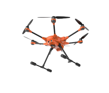
Yuneec’s flagship mapping drone comes equipped with all the works: an RTK module, a dual GPS-GLONASS module, and a Network RTK Base Station. You can either get the H520 RTK package as a whole or upgrade your existing H520 with the hardware to make it RTK-capable. Either way, you get to enjoy the advantage of superior mapping technology onboard Yuneec’s signature hexacopter drone design.
From its branding, it’s obvious that the H520 RTK was designed for real-time data correction using an RTK workflow. However, the system also supports logging of uncorrected GPS data so you can easily make the switch to PPPK. This makes the H520 RTK an all-around tool for mapping, whether your survey is on a vast open field or an urban area with lots of obstacles. The RTK technology also makes it possible to capture fewer aerial photos, resulting in shorter survey periods.
The choice of the H520 as the platform for RTK and PPK technology provides extra versatility to the mapping professional. The H520 is one of the more flexible drones from Yuneec due to its range of compatible payloads. These include the E90 20MP high-speed camera, the E50 12 MP camera, and the CGOET thermal imaging and low-light camera with dual video stream capabilities.
At around $3200, the complete Yuneec H520 RTK package with the drone and all the additional hardware is one of the most affordable options for RTK mapping. With the turnkey package, everything comes assembled, calibrated, and ready to fly.
2. DJI Phantom 4 RTK
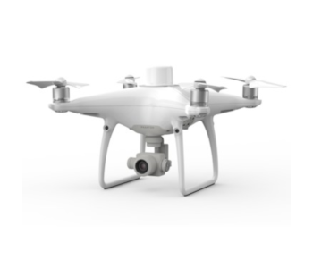
The Phantom 4 RTK was released by DJI late last year and threatened to take the mapping world by storm. Anchored on DJI’s excellent reputation for coming up with innovative features, the Phantom 4 RTK promised to revolutionize survey mapping by being the most compact and accurate mapping solution.
The package of the Phantom 4 RTK includes an RTK module, a D-RTK2 GNSS Mobile Station, a camera with a 1-inch CMOS sensor, and the GS RTK mobile app for survey planning and data quality monitoring. As with other RTK options, DJI claimed to be able to achieve centimeter-level accuracy when mapping with the Phantom 4 RTK.
Again, it was quite apparent that the Phantom 4 RTK was designed for real-time data correction using an RTK workflow. Acknowledging that RTK may not be possible for all survey areas, DJI allows for storage of satellite observation for PPK post-processing.
The issue, which many drone mapping professionals have an encountered, is that the PPK functionality of the Phantom 4 RTK has proven to be difficult to use. The incompatibility of the Phantom 4 RTK with PPK has prompted them to form a partnership with Propeller to develop a fully integrated upgrade for the drone that allows PPK processing. This will require the use of Propeller’s proprietary AeroPoint GCP system.
While the upgrade works great and has received generally good feedback, it adds even more to the cost of the Phantom 4 RTK, which already costs more than $6000. It’s still an excellent product backed by DJI’s high-quality standards, but it’s really best used in a setting that allows for real-time RTK workflow. If you prefer the versatility of PPK, then you’re better off looking elsewhere.
3. PPK Upgrade from Baam.Tech
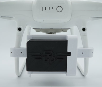
If you already have a professional-grade drone like the DJI Phantom 4 Pro, Inspire 2, or the Matrice 200, then you are probably less inclined to buy a brand new drone just to upgrade to PPK. Fortunately, the fine folks of Baam.Tech are offering a complete upgrade package for these popular drone models. Starting at $2500, this may be one of the most affordable ways to enhance your mapping capabilities with PPK provided that you already have a drone.
The Baam.Tech PPK is highly modular and slides right in an out of an attached mount. The little module has a combination of GPS, GLONASS, BeiDou, and Galileo that take advantage of multiple constellations of GPS satellites to make data more reliable and data acquisition much faster. It is hardwired to the shutter of the camera so that all photos are automatically geo-tagged.
When you purchase the PPK upgrade, it comes with Baam.Tech’s very own PPK software that will process all corrections and make the necessary changes to the metadata of each geo-tagged image. The data from this PPK software is compatible with most photogrammetry software.
The modular design of the PPK technology allows you to remove it from the drone and use it for accurate location measurement of any GCPs you might want to include in your survey. This is a nice little feature that can certainly be useful in the long run.
The bad news is that the default PPK package does not come with a ground station. Instead, the PPK module communicates with any existing CORS station in your survey area. This shouldn’t be as much of an issue as most places in the US are within the scope of a CORS station. However, if you really need your own base station, it’s going to cost you an additional $2500.
All in all, Baam.Tech offers a very affordable alternative to current PPK technology. Its main limitation is that it relies on two critical pre-requisites: that you already own a compatible drone, and that your target survey area has a nearby CORS station. If this the case, then by all means, the PPK upgrade from Baam.Tech is an excellent option.
Final thoughts
The industry of drone mapping has certainly grown by a huge leap in the past couple of years in terms of both scope and technology. Basic GPS-guided photogrammetry used to be the norm, but recent advances in sensor and navigation technology have started to challenge this standard. The PPK method is one such challenger.
Although PPK and RTK use the same hardware, the difference in how they implement data correction is enough reason for one to be preferred to the other. PPK has the advantage of being more versatile in terms of survey execution and allows for the maintenance of a more robust survey database.
There are more than a dozen manufacturers who either sell turnkey PPK solutions or provide an upgrade to existing drones. Whichever option you choose, one thing you need to know is that it will cost quite a lot. In most cases, a PPK module will be several times more expensive than your drone. Consider it an investment – after all, you’ll end up being one of the few drone mapping professionals with PPK capabilities.