How to Do Aerial Surveys and Multispectral Imaging with Drones

With the rapid increasing popularity of drones, it comes as no surprise that they have become recognized as useful tools in number of commercial and industrial applications. Nowadays, one of the most common uses of drone technology has been in aerial surveys – the collection of large amounts of geospatial data using drones equipped with various sensors and cameras. Drone-based surveys can be conducted to produce a variety of useful outputs for use in equally varied industries.
In this article, we take a detailed look at how to choose the best drone for conducting a drone-based aerial survey. We have also compiled a short list of the best drones available for different drone survey applications.
What are drone surveys?
Simply put, drone surveys are aerial surveys carried out by unmanned aircraft. This is a relatively new approach to the long-established practice of mapping and surveying. Before the advent of drones, surveyors had to physically access pre-determined points within the area of interest. Measurements were made at the ground level, making it necessary to carry around often heavy and bulky survey equipment. This was a method that took a lot of time, was physically exhausting to the surveyors, and exposed the surveyors to hazards inherent to some survey areas.
In the latter part of the 20th century, the development of remote sensing allowed surveyors to gather data without having to physically access the survey areas. This was made possible using sensors and cameras onboard satellites and manned aircraft. Although this approach created results faster and was safer for the surveyors, it was also very expensive. Depending on the flight altitude and sensitivity of the sensors, the old methods of remote sensing also suffered from poor data resolution and poor repeatability of results.
Drone technology has practically ushered a new age of remote sensing. It provides the same benefits of generating results faster and in a safer manner, but also allows for low altitude flights for better data resolution. Moreover, drones are much easier to operate compared to manned aircraft, making the service far more accessible. GPS-guided drones can be programmed to fly on pre-determined paths, making aerial surveys repeatable and consistent.
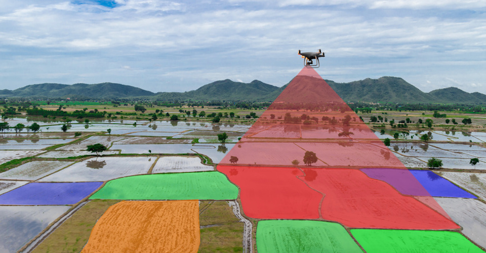
Drone surveys are commonly done by setting the boundaries of the survey area or by setting the flight path for the drone. Onboard sensors gather data on the survey area as the drone flies along the area of interest. These data can be in the form of overlapping high-resolution images, multispectral images, data point clusters, or gravity data among others.
In any case, data collected in drone surveys are considered ‘geospatial’ in nature – or associated with a particular point in a geodetic coordinate system. The geotagging of every pixel in an aerial image allows dedicated software to reconstruct models that are ultimately more useful to the end-user. Possible outputs include 3D models, digital elevation models, NDVI maps, and so much more.
What are the common types of drone surveys?
The term ‘drone survey’ is an umbrella that incorporates diverse drone-based applications. Aside from using drones to collect data, these applications can have nothing else in common. They use different sensors, survey methods, and processing software. Listed below are some of the most common types of drone surveys:
1. Photogrammetry
In a photogrammetry survey, the drone’s onboard high-resolution camera takes a series of overlapping images of the survey area. With an overlap rate ranging from 60% to 90%, a post-processing software can determine the depth of individual features in the images. The resulting output is a fairly accurate 3D model of the survey area that displays a full range of colors. Photogrammetry is a simple and accessible technology that creates fully navigable 3D models that are also visually appealing.
2. LiDAR
Light Detection and Ranging (LiDAR) refers to an aerial mapping method that employs a sensor that continuously emits pulses on non-visible light as the drone flies over the survey area. These pulses of light are then reflected off the individual features of the area of interest and are again measured by the sensor. The data on the times it takes for individual light pulses to return to the sensor are processed by a dedicated software to determine the size and shape of the features in the survey area. The output is a data point cluster that is essentially a very accurate 3D model of the area of interest. However, the resulting 3D model is monochromatic, so it lacks the visual flair of a 3D model generated using photogrammetry.
3. Roof inspection
Roof inspection is a specialized niche of drone mapping that is dedicated to capturing a detailed model of a roof. This process is often done as part of roof maintenance, insurance claims, or installation of solar panels. A photogrammetry technique is usually more practical for the small scale of roof inspections jobs. The expected result is a highly detailer 3D model that roof inspectors can use to make accurate measurements and to identify problem areas for repair. For infrastructure improvement, such as the installation of solar panels, a detailed roof inspection model allows contractors to provide more realistic cost estimates.
4. Thermal imaging
As the name implies, thermal imaging refers to the generation of a “heat map” of the survey area. This can be done as part of a construction inspection, search and rescue operations, inspection of power lines and communications tower, and for security and surveillance. Thermal imaging has the potential of identifying “hot spots” in critical structures that could be an indicator of heat leakage in building insulation or incomplete transmission in power lines. A thermal imaging survey requires the use of a special thermal infrared camera that can measure the amount of infrared radiation emitted by objects. Infrared radiation is a non-visible energy, so thermal cameras commonly translate this data to a colorized heat map for easier interpretation.
5. Precision agriculture
One of the fastest rising applications of drone surveying is in precision agriculture. This refers to the collection of large amounts of data on crop health that can aid in farm management and resource allocation. Drones aid in precision agriculture by capturing aerial multispectral images. This involves the use of sensors that can capture images using non-visible spectral bands, such as near-infrared and red edge. These bands are absorbed and reflected by vegetation at varying degrees depending on how healthy they area.
By generating contrast maps using multispectral data, farmers can quickly and easily spot problem areas in their field. This information allows farmers to more efficiently allocate their resource such as fertilizers and pesticides. It can also help farmers harvest their produce at the most optimal time for better quality.
What should I look for in a survey drone?
Aerial surveys may be some of the most challenging applications for a drone. They must cover large areas and contend with challenging flight conditions while continuously recording data or capturing images. For this reason, drone surveys are often carried out using high-end enterprise-level drones. The following are the most important characteristics you should look for when choosing a survey drone.
1. GPS-guidance
One of the best features of using drones for aerial surveys is the ability to command the drone to cover a pre-determined survey area or flight path. This eliminates the burden of manual drone flight while ensuring that surveys are repeatable and are not subject to human errors and inconsistencies. For a drone to carry out an automated flight command, it needs to come equipped with GPS guidance technology. Fortunately, even most entry-level drones are equipped with GPS, so a high-end model should give you no problems in this department.
2. Long battery life
Survey drones often must cover huge areas, especially in precision agriculture and mapping surveys. Many survey projects are so large that it is often necessary for the drone to return to home in the middle of the survey to have its batteries replaced. Using a drone with a long battery life minimizes the number of the times that a survey needs to be interrupted for battery replacement. We recommend using a drone with that can fly for at least 25 minutes on a single battery cycle.
3. Flight stability
Most drone surveys must be conducted in large, open areas such as farms, forests, and mountains. Surveys can also often take several hours to finish, which means that the survey drone will likely be subjected to challenging weather conditions such as strong winds or light rains. Using a drone that cannot maintain a steady altitude in these conditions may result in poor data quality. We recommend using a model with six-axis gyro stabilization that combines the capabilities of a 3D gyroscope and 3D accelerometer. This helps keep the drone flying steady while reducing drift and the effect of vibrations.
4. Customizable payload
While photogrammetry surveys can be conducted using the stock cameras of most high-end camera drones, a drone that has a provision for a customizable payload offers much more versatility in terms of commercial applications. Popular drone brands such as DJI, Parrot, and Yuneec sell an array of interchangeable payloads for different survey applications such as thermal cameras and multispectral sensors. However, there are only a few select drones that can accommodate different payloads.
5. Software bundle
Survey drones are rarely stand-alone products since they rely heavily on software for survey planning and post-processing of data. For this reason, we recommend survey drones or sensors that come bundled with all the necessary software. A mobile app for survey planning and real-time survey monitoring is particularly useful for carrying out automated drone flight missions. Post-processing software often come with a subscription-based pricing model that gives end-users access to a growing library of functions and processing algorithms. Cross-compatibility between the different software platforms you will be using is also something you need to ensure.
What are the best drones for drone surveys?
1. DJI Inspire 2
The Inspire 2 from DJI is considered by many as the gold standard of professional-grade drones. It retains the excellent form factor of the original Inspire but now comes with tougher but lighter carbon fiber arms and an aluminum composite body. The Inspire 2 is an incredibly fast machine that can reach speeds of up to 58 mph. It also has an extended flight time of up to 27 minutes on a single battery cycle. The remote controller of the Inspire 2 gives it a maximum range of up to 7 km, allowing you to survey a huge land area from a single vantage point.
The Inspire 2 has a provision for interchangeable payloads that is compatible with the Zenmuse X5S and Zenmuse X7 cameras. These are both top-of-the-line cameras that can capture 24MP still and videos at 5.2K resolution. The superior image quality of the Zenmuse cameras allows for an excellent Ground Sampling Distance for photogrammetry surveys.
2. DJI Matrice 200
In many ways, the Matrice 200 can be considered an upgrade to the Inspire 2. It is slightly heavier and bigger, but the Matrice 200 is also tougher and more rugged. With its IP43 rating, 17-inch propellers, and powerful motors, the Matrice 200 can withstand the roughest and most inhospitable conditions. Moreover, the Matrice 200 can be equipped with the TB55 battery that lets it fly for an impressive 38 minutes in ideal conditions.
The biggest advantage of using the Matrice 200 is its increased versatility in handling different payloads. In addition to the Zenmuse RGB cameras, the Matrice 200 can also support the Zenmuse XT thermal camera and the Zenmuse Z30 integrated zoom camera. The onboard SDK can even be customized to expand the hardware and software capabilities of the Matrice 200, allowing to support third-party sensors such as LiDAR and multispectral cameras.
3. Yuneec Typhoon H520
The Typhoon H520 from Yuneec sets itself apart from most of its contemporaries with its signature hexacopter design. Despite its size, it remains relatively lightweight with a takeoff weight of less than 2 kg. The Typhoon H520 can fly up to 30 minutes on a single battery cycle, although this figure may decrease down to 28 minutes when the cameras are in full use. The ST16S remote controller comes with an integrated 7-inch LCD screen that displays all the relevant telemetry data and provides a range of up to 1.5 km. The addition of the Intel RealSense obstacle avoidance technology to the Typhoon H520 makes this drone inherently safer and easier to fly.
The Typhoon H520 also has very good payload versatility. Users may opt for one of three camera options available: the E50 camera with 1/2.3-inch sensor, the E90 camera with 1-inch CMOS sensor, or the CGO-ET camera with dual thermal and visual imaging capabilities. This makes the Typhoon H520 one of the most useful drones for a variety of survey applications.
4. DJI Mavic 2 Pro
In the field of ultraportable drones, there is currently no model that can rival the Mavic 2 Pro in terms of camera quality. It is the only foldable drone equipped with a Hasselblad camera with a 1-inch CMOS sensor and can capture 20MP stills and 4K video. It is also supported by an updated 3-axis gimbal for maximum field of view. Combined with an omni-directional obstacle avoidance system, the Mavic 2 Pro is truly one of the professional-grade drones that just happens to come with a highly portable design.
The Mavic 2 Pro does not inherently come with an interchangeable payload provision. However, third-party manufacturers of multispectral sensors such as Sentera offer upgrade services for the outfitting of additional sensors on the Mavic 2 Pro. These sensors can be used to collect data for precision agriculture NDVI or NDRE mapping.
5. Parrot Bluegrass Fields
The Bluegrass Fields from Parrot is an especially designed portable drone for precision agriculture surveys. It is equipped with two cameras: an RGB camera that can capture 14MP images and 1080p videos, and the Parrot Sequoia multispectral sensor that can capture 14MP videos using invisible spectral bands. The Sequoia also has a sunlight sensor for data calibration against lighting conditions, as well as an integrated GPS and IMU for accurate geotagging of data.
Although the Bluegrass Fields was designed for precision agriculture surveys, its RGB camera can also be used to capture images for photogrammetry. Since the Bluegrass Fields is limited to capturing images at 14MP resolution, the quality of the model reproduced using photogrammetry is lower than what you would expect from camera drones. Still, it gives the Bluegrass Fields some degree of versatility in terms of commercial applications.
The Bluegrass Fields also comes with the Pix4D mobile app for survey planning and execution, and the AIRINOV FIRST+ application for data processing and map generation. Overall, the Parrot Bluegrass Fields drone bundle provides excellent end-to-end support for commercial drone mapping.
Final thoughts
Drone technology provides benefits in probably all aspects of mapping, which has made drone mapping one of the fastest rising commercial drone applications. Mapping surveys done with drones are faster, cheaper, and logistically less demanding. They are also inherently safer for surveyors, as they no longer need to physically access the whole survey area which may expose them to terrain and wildlife hazards.
The agriculture industry has been one of the major recipients of the benefits of drone-based surveys. Through precision agriculture, farmers can gather a large amount of data on crop health quickly and accurately. This information aids them in efficiently allocating resources such as fertilizers and pesticides, as well as in forecasting the best time to harvest their produce.
Picking the best drone for mapping is a matter of choosing the best combination of long battery life, autonomous flight functions, and provision for a customizable payload. If this is an industry that interests you, then we hope our short list of the best models for drone surveys could help you. This field shows great promise, and we expect it to continue to grow in the next few years.