5 Best Agricultural Drones

Drones are increasingly being used in industrial applications. The agriculture sector is particularly embracing drones to improve efficiency. Despite being one of the more unexpected applications of drone technology, the global agricultural drone market has been forecasted to grow in value from $500.71 million in 2017 to around $4.6 billion in 2025, corresponding to about 32% annual growth. With more brands coming out with specially designed agricultural drones and an increasing awareness of how drones can benefit the agriculture industry, it is reasonable to expect a huge margin of growth for this commercial drone application.
In this article, we take a detailed look at what agricultural drones are, how they work, and how they are used. We also compile a list of the best agricultural drones that are available today.
What are agricultural drones and how do they work?
Agricultural drones are used by farmers to conduct quick and detailed evaluation of the health of their crops. These agricultural drone surveys can reveal problems with irrigation, pest infestation, or soil variation. Some agricultural drone models even come with software that can provide location-based prescription after the survey data has been processed, allowing farmers to step in with informed corrective actions. Ultimately, agricultural drones are valuable tools that farmers can employ to improve crop yields and farm efficiency. In an era where world hunger and food scarcity are pressing issues, the technology of agricultural drones has become more relevant than ever.
Although the use of drones for agricultural applications seems live a novel idea, the technology behind it has actually already been use since the early 2000s. The normalized difference vegetation index (NDVI) is a metric derived from multispectral analysis of aerial images of crops. It has been used by the LANDSAT satellites for more than a decade to assess the global health of rainforests. At a smaller scale, the NDVI can be used by farmers to identify ‘problem areas’ in their fields.
In addition to capturing visible light, NDVI cameras can also capture near-infrared light, which is at a wavelength slightly outside the visible spectrum. The theory behind it is that healthy plants and crops absorb a higher amount of visible light due to the presence of the chlorophyll pigment. Thus, they reflect a lower amount of visible light and a higher amount of near-infrared light.
NDVI values can fall within the range -1.0 to 1.0. Typically, the NDVI values of healthy crops have a value between 0.3 to 0.8. Values lower than these are indicators of unhealthy vegetation or may be an artifact of multispectral images captured over clouds or bare soil. Bodies of water have approximately equivalent reflectance of both visible and near-infrared light, resulting in NDVI values near zero.
What is precision agriculture?
The use of agricultural drones forms the backbone of a field called precision agriculture. This is a concept of farm management that relies heavily on observing and measuring temporal and spatial variations in a farm field and formulating a decision support system to respond to the issues and findings. In addition to improving crop health, this system also aims to improve efficiency by optimizing inputs and minimizing the use of resources.
By collecting a large amount of data, precision agriculture brings all the benefits of “big data” to the farming industry. The entire ecosystem of precision agriculture goes beyond just the drones, but includes the software needed to integrate the data collected by drones into easy-to-comprehend maps and models. More sophisticated software can even simulate farm conditions using time-series data to come up with forecasts.
The most apparent benefit of precision agriculture is the practice of variable-rate spreading techniques for fertilizer. With GPS-aided identification of problem areas, farmers can choose to distribute their fertilizer on areas that most need them. Fertilizer meant for otherwise healthy areas can even be allocated to problem areas, thereby optimize its use.
The United States, Canada, and Australia have been in the forefront of adoption of precision agriculture technology, with countries in Europe and Latin America following soon after. In Asia, China has been the only major country that has embraced this technology, although the rate of adoption is still lagging. The high initial cost of precision agriculture has been identified as the main reason for the resistance in its adoption especially for developing countries.
Members of the agriculture industry remain optimistic that maturing agricultural drone technology will make it more accessible and easier to integrate into current farming techniques. Governments can also play a part in promoting this technology by providing incentives to early adopters, thereby absorbing some of the financial risk.
Fixed wing or rotary drones?
Early drones used for agricultural surveys were mostly fixed wing models, but the recent years have seen rotary drones become a significant presence in the field. However, despite the greater popularity of quadcopters, precision agriculture is one of the few fields where fixed wing drones have remained fairly popular.
Fixed wing drones have a major advantage working for them: they can fly longer and farther than rotary drones. Much like airplanes, the carefully engineered shape of the wings of fixed wing drones generate lift as they move forward. This means that the propeller motors of a fixed wing drone only need to provide forward motion. Typical fixed wing drones can fly for 30 to 40 minutes, much longer than the 15 to 25 minutes typically achieved using rotary drones.
In addition to having a longer battery life, fixed wing drones can also move faster. This allows them to cover huge areas, up to 60 hectares in a single battery cycle. With the use of a fixed wing model, an agricultural drone can collect data on a farm that will take more than a week if done manually. The wing design of fixed wing drones also allow them to glide smoothly towards a safe landing spot should they run out of batteries.
However, the high speeds of fixed wing drones also proves to be a disadvantage. With fixed wing drones, a drone pilot has no option to hover or slow down to a sufficiently low speed to capture high resolution images. They are generally larger than rotary drones, making them less portable and inconvenient to carry around.
On the other hand, rotary drones have the advantage of superior maneuverability. Aside from being able to make vertical take-offs, rotary drones can hover, slow down, and make very sharp changes in direction. This allows a drone pilot to make a very tight flight path. The slower speed that rotary drones can achieve can increase the overlap rate of aerial images captured, making higher-resolution reconstructed models that are also more accurate.
The major disadvantage of a rotary drone is its short battery life. A rotary drone’s propellers are responsible for both lift and propulsion, requiring a high power output. Even high-end rotary drone models are only capable of a battery life of 30 minutes or less. For large farms, completing a comprehensive survey will take frequent return-to-home trips for battery replacement. Although the same goals can be completed, it will take a much longer time when done using a rotary drone.
One thing to remember, whether you choose a fixed wing or rotary drone, is that agricultural drones can be very expensive. After all, these are professional-grade drones equipped with automated flight options and a camera that can capture near-infrared light. You will also need a software or app for survey planning and post-processing of data. All these features put agricultural drones at a price range that is way outside of what casual users can afford.
The best agricultural drones available today
The agricultural drone field being a niche market, there are not a lot of options for buyers looking for agricultural drones. We have compiled a list of the best and most popular agricultural drones available in the market today to help you pick the best model for you.
1. DJI Smarter Farming Package
The DJI Smarter Farming Package is a consolidation of some of DJI’s existing drone technology to address the needs of precision agriculture. The package contains a standard DJI M100 drone that is equipped with both a visual sensor and a multispectral sensor. It also comes with a one-year subscription to DataMapper Standard, a software platform that can be used to generate 2D and 3D maps. The software also has a huge library of analysis tools for NDVI and other, more advanced indices. By combining the results of the different analysis tools, farmers can come up with more nuanced and informed decisions.
The package also comes with DataMapper Infield, a desktop and mobile application that lets you define the flight path coverage of the survey and add specific ground control points for model calibration. If you want to see the results of your survey right away, the DataMapper Infield also lets you view real-time results from your mobile device.
The inclusion of the M100 drone allows you to conduct an agricultural survey using one of DJI’s premium professional-grade drones. It comes fully assembled and ready to fly. Being one of DJI’s premiere drones, the M100 has intuitive and easy-to-learn controls and delivers a remarkably stable flight experience. The M100 can run fly up to 35 minutes in a single battery cycle.
2. Sentera NDVI Upgrade for DJI Drones
If you have an existing DJI drone that you want to use to do an agricultural survey, then you may opt to get the NDVI camera upgrade from Sentera. This upgrade is compatible with the Mavic Pro, Phantom series, the Inspire 2, and the M200 series. Basically, the upgrade consists of the installation of an NDVI camera at the bottom of the drone, leaving your stock camera untouched and giving your drone the capability to capture near-infrared images.
The 1.2 MP Sentera NDVI camera holds the distinction for being the smallest and lightest precision agriculture sensor available today. You can rest assured that the flight performance of your drone will hardly be affected by the addition of this sensor. When you purchase this upgrade, Sentera will handle the installation of the sensor in your existing Phantom or Mavic drone. If you own an Inspire drone, the NDVI camera with its stabilizing gimbal can be easily attached into the Inspire’s existing socket.
Purchasing the Sentera NDVI upgrade also gives you 1 year of subscription to the FieldAgent software which you can run from a mobile device or a desktop computer. The FieldAgent software can be used to generate NDVI maps to provide insights on crop health. Advanced data processing capabilities also provide elevation mapping, weed detection, zone mapping, and population analysis.
The Sentera NDVI upgrade may be one of the most affordable means of getting your very own precision agricultural drone, especially if you are already an owner of a professional-grade DJI drone.
3. Parrot Bluegrass Fields
Parrot has jumped in the ahead of many mainstream drone brands in the field of agricultural drones by leveraging the strength of their Parrot Sequoia multispectral sensor. Their Bluegrass Fields quadcopter provides an end-to-end precision agriculture solution by combining the Parrot Sequoia with a front-facing RGB camera. It is a rugged and easy-to-fly drone that can cover up to 65 hectares in a single battery cycle.
The Parrot Sequoia sensor allows the Bluegrass to capture images in four distinct-mono bands: Red, Green, Red-Edge, and Near-Infrared. With the amount of data captures in each survey run, the Bluegrass delivers a wealth of information in a matter of minutes. The high-resolution camera can achieve a ground sampling distance (GSD) of 11.5 cm per pixel at 122 m altitude, which can be improved to 2.8 cm per pixel at 30 m altitude.
After the multispectral analysis has identified problem areas, you can use the front-facing 14MP camera to take high-quality images for detailed visual inspection. With the ability to capture videos at 1080p resolution, the Bluegrass can even act as a live surveillance drone for identification of easily observed problems such as pests or wild animals.
The Parrot Bluegrass Fields drone package comes with the ParrotFields mobile app, a valuable tool for quick and easy survey planning. While the drone is in flight, the ParrotFields app makes it possible to view in real-time the NDVI map being generated by the data being collected. This allows you to step in at any point during the survey to conduct more detailed surveys on problem areas. You can add text annotations to the data, and even append geotagged photos taken by the drone or from the ground.
After data capture, a detailed analysis can be done using the PIX4DFields drone mapping software. This allows you to produce custom index maps, conduct temporal analysis of crop health behavior, and come up with prescription maps that can be seamlessly integrated with most Farm Management Information Systems (FMIS).
4. Parrot Disco-Pro Ag
The Parrot Disco-Pro Ag is essentially the fixed wing counterpart of the Bluegrass Fields. It is also equipped with Parrot Sequoia multispectral sensor for detailed crop analysis. The drone’s dedicated 16 MP RGB camera allows it to capture high-resolution photos and videos for crop surveillance and visual assessment. True to the benefits of being a fixed wing drone, the Disco-Pro Ag can travel up to 80 hectares in a single battery cycle, nearly 4 times longer than the Bluegrass Fields.
Flying the Disco-Pro Ag is not difficult at all. It does not require a long take-off strip, as it can be easily hand launched. An automated landing system also means you do not need excellent landing skills. After you are done collecting crop data, you have the option of shifting the location of the Parrot Sequoia sensor to the top side of the drone. This allows you to collect sunlight intensity data for radiometric calibration of the multispectral data. The correction results in more accurate data, and a more informed prescription model.
The Disco-Pro Ag offers no platform for real-time generation of NDVI maps, but it does come with the cloud-based Airinov First crop analysis platform. Being entirely cloud-based, syncing the crop data to the Airinov and generating NDVI maps can be done almost instantly. The software can also generate other maps, such as a variable-rate application map for fertilizers.
The Disco-Pro Ag contains all the excellent technology that Parrot has on multispectral analysis of crop images and generation of prescription maps. Being a fixed wing drone, it is the recommended model for excessively large farms.
5. senseFly eBee SQ
The eBee SQ is probably one of the best and most expensive agricultural drones that a farmer could use. The senseFly company, being under Parrot, also uses the Parrot Sequoia multispectral sensor with the eBee SQ. However, it stands out from the other Parrot agricultural drones with its ability to cover up to 200 hectares in a single battery cycle. This makes it an extremely efficient tool for covering very large farm areas.
The drone package comes with the eMotion Ag, an integrated software platform that has survey planning capabilities while being able to connect to cloud-based solutions to download real-time airspace data and weather updates. It is fully compatible with most FMIS platforms and agricultural machinery, so the gathered data can be integrated into your existing workflow seamlessly.
The use of 5 bands (4 visual, 1 near-IR) of the Parrot Sequoia sensor allows the eBee to gather so much data in just a single flight. The gathered data can be processed using the Pix4DFields software to generate not just NDVI maps, but also digital elevation models, orthomosaics, 3D point clouds, Google Maps files, and prescription maps.
If you want to have a drone that will finish your precision agriculture jobs quickly and efficiently, the senseFly eBee is just the right drone for you. There are few drones that can rival its 110 kph maximum speed and 55-minute maximum flight time.
What does the future hold?
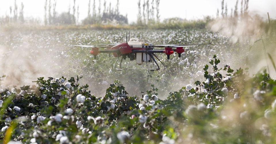
Although drones that conduct multispectral analysis have been a great help for farmers for crop management, we can foresee a future where drones can do so much more. In fact, that future is probably already here with the DJI Agras MG-1, a drone that can carry a 10 kg payload and spray fertilizers, pesticides, or herbicides across 7 to 10 acres of farmland per operation. With the ability to easily set the area for it to spray its payload, there is probably no other crop spraying method that can rival the efficiency of the DJI Agras.
Currently, there are no other mainstream drone brands that offer a product like the DJI Agras. It probably won’t be long before competitors show up, though. We are optimistic that future developments can even combine the technology of NDVI analysis with crop spraying drones for a literal on-the-fly crop health analysis that controls the rate at which fertilizers are sprayed.
Aside from the frontier of crop spraying drones, we also anticipate that agricultural drones in the future will be equipped to handle longer flights. Flight range is currently the battlefield where different agricultural drones have been trying to one-up each other, and this is a competition we would like to see continue.
Right now, a major hurdle in the widespread adoption of agricultural drones is the high price. The senseFly eBee costs more than $10,000, while the Sentera upgrade for DJI drones can cost anywhere between $1500 to $5000. We are optimistic that the increasing competition for drone manufacturers in this field will eventually drive the price down to a level that makes the adoption of this technology easier, especially for the developing countries that need it the most.
Final thoughts
The application of drone technology to agriculture seems unusual, but it’s hard to argue with its benefits. By harnessing drone technology, farmers can get up-to-date and detailed data on the health of their crops in a matter of minutes or hours instead of the weeks it would take to gather data the traditional way. This concept presents a radically successful integration of modern technology to a very old-fashioned industry.
Although the technology has been used in several countries for many years, there is still a huge potential for the agricultural drones to develop so they can be used for other applications. The DJI Agras shows us the future because it’s essentially a crop duster compressed into the size of a drone that can carry out automated commands. The high cost of this technology has also made it hard to access for some markets, particularly developing countries whose economies rely largely on agriculture. With world hunger and food scarcity becoming more and more relevant problems, agricultural drones are the type of technology we’d like to see hit the mainstream.
Good to hear that drones works in agricultural
What kind of Drone is in the Display Picture?
It is not any of the listed TOP 5 Agricultural Drones
Apart from Drone deploy, what is the next best in the way of software?
Haha,Except DJI from China,we are only focus on agricultral drones with own manufactory in Shenzhen,China,Look forward to further information about exploring others:)