The Pros and Cons of Drone Use in Agriculture

Among the many applications of drone technology, there are perhaps only a few that are as socially relevant as agriculture. Drones allow farmers to gather a huge amount of data on crop health, which help them make more informed decisions on farm management. With the help of drone technology, farms can yield better produce, use their resources more optimally, and ultimately enjoy increased profits.
However, using drones for farm management is far more complex than taking aerial photos and videos. In fact, extracting useful information from the data gathered by drones involves a complex process which may not be for everyone. To assess if a drone-based solution will work for your particular farm application, we have listed down all the pros and cons of using drones for agriculture.
How are drones used in agriculture?
The ability of drones to fly over vast areas and distances in a short amount of time make them especially suited for data gathering in farms. Whether it’s through the use of standard cameras or more specialized sensors, drone-based surveys can aid farmers in inspecting and gathering data on their crops at a fraction of the time it would have taken using more traditional methods.
Most drone-based farm management applications gather data using multispectral sensors. As its name implies, a multispectral sensor can “see” images beyond the visible spectrum. This means that it can capture images of electromagnetic energy that the human eye cannot see.
The most commonly used frequency band used to assess crop management is near-infrared, or near-IR. The use of sensors that are sensitive to different frequency bands is based on the premise that different surfaces have different rates of absorption and reflectance of different bands of energy. For instance, healthy plants rich with chlorophyll pigment typically absorb a higher amount of visible light. Conversely, these healthy plants absorb a smaller amount of near-IR energy. Unhealthy plants and bare soil show the opposite behavior, they absorb a higher amount of near-IR energy, but absorb a very small portion of visible light. Energy that is not absorbed by the plants is reflected, and this reflected energy is what the multispectral sensors capture.
By using multispectral sensors, drones can capture aerial images that show the contrast of reflected near-IR energy across several regions of a single farm. These images show a highly informative summary of the state of crop health in the farm, letting the farmer know if there are particular areas or crops that require increased irrigation, or treatment by fertilizers and pesticides. This allows the farmer to more optimally allocate resources according to which crop or which area of the farm needs it the most.

Nowadays, more sophisticated multispectral sensors can capture even more discrete energy bands such as red-edge and thermal infrared. In addition to being able to identify unhealthy crops and water-starved areas, the data gathered by these advanced multispectral sensors can even let farmers know when the best time is to harvest their produce.
What are the pros and cons of using drones for agriculture?
Despite the perceived usefulness of drone technology for farm management, its adoption has still been limited. To understand why the technology has not been embraced by many farmers yet, we need to look at the limitations that come with its benefits.
Pros
1. Better data quality
Multispectral drone surveys have ushered in a new era of unequaled data quality and accuracy, delivering data that is beyond what manual surveys can gather. As mentioned, the energy bands that multispectral sensors can capture are beyond what the naked eye can see. Modern multispectral sensors are typically paired with RGB sensors – high-quality cameras capable of high-resolution aerial photos. Overlaid on top of each other, these multispectral images and high-resolution RGB images can be interpreted to deduce a lot of valuable farm management information.
What makes multispectral surveys using drones unique is the fact that drones can hover at much lower altitudes. In the past, multispectral imaging has been done from onboard a manned aircraft. Satellite images have also been analyzed to see visual aberrations between different areas of a single farm. Obviously, the higher altitudes where the data from these methods were captured means that the data has lower resolution.
2. Flexible analysis
Although multispectral data is typically presented as visual maps showing the intensity values distributed across the survey area, behind this visual representation is a point cloud consisting of thousands of individual data points. The numerical nature of the data means that they can be manipulated, combined, and interpreted in several different ways. Beyond being a tool that can be used to measure crop health, multispectral data can also be interpreted to assess soil moisture or the severity of pest infestation.
Multiple multispectral surveys can be conducted in a single survey area to see changes over time of some useful parameters. The numerical nature of the multispectral data means that meaningful changes over time can be quantified. These changes can be as simple as improvements of crop healthy, or more subtle ones such as drastic changes in normalized difference red edge (NDRE) values caused by fruits reaching their maximum sugar content.
3. Easier to deploy
Before the use of drones, farmers who wanted to conduct aerial surveys of their farms for multispectral imaging had no choice but to do them using manned aircraft. Not only is flying manned aircraft more expensive, but it is also more logistically complicated. Between looking for a pilot capable of flying the aircraft, securing permission from air traffic, and taking off from a sizable air strip, operating a manned aircraft takes a lot of time, effort, and manpower.
On the other hand, using a drone could be as simple as finding a good spot to launch the drone, setting up a pre-determined flight path, and letting the drone do most of the work. There may still be scenarios where you will need to secure air traffic permission, such as when the drone farm is within restricted airspace, but flying a drone is generally much simpler than flying a manned aircraft.
Further emphasizing how easier it is to fly a drone is the fact that both drones and multispectral sensors are getting smaller, lighter, and more user-friendly. Many sensor manufacturers, such as Sentera and MicaSense, offer highly portable multispectral sensors that are compatible with the most popular drone models available today. Cloud-based data processing solutions have also made it possible to perform complex data analysis even without high-end hardware.
4. Can help reduce operational costs
Whether you choose to do a drone survey or to stick to more traditional methods, monitoring crop quality will always lead to reduced operational costs. By monitoring crop health, farmers can allocate resources more optimally. By identifying problem areas early, farmers can reduce losses due to infestations, diseases, or poor irrigation. By keeping crops healthy, farmers also enjoy the benefit of better farm yield, in terms of both quantity and quality.
Although using drones may involve a high start-up cost, it is still the more economical solution in the long run. Doing aerial surveys using manned aircraft will certainly be more expensive, as it will require more expensive equipment and more manpower. Ground-level crop monitoring will also take a lot of manpower and will take a longer time to gather a less comprehensive dataset. Right now, only drones can hit that sweet spot of being an affordable method that can also deliver high quality and accurate results.
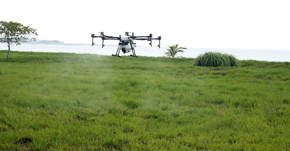
5. Crop spraying
Although the technology is not that common yet, there are drone models that can be used to spray chemical treatment on crops. This is done by having a drone carry the liquid fertilizers or pesticides as a payload. The drone operator can then set a pre-determined flight path through which the drone sprays the treatment in a controlled manner. Some models even come with an algorithm that varies the spray rate according to the drone’s flight altitude, ensuring that all the crops receive an equal amount of treatment.
The DJI Agras MG-1 is probably the most popular drone that falls under this classification. It can carry a 10 kg. payload and spray this payload across 7 to 10 acres in a single battery cycle. We think that the DJI Agras is but a preview to the future of agricultural drones, where drones can do so much more than just gathering data.
Cons
1. High Initial Investment
The biggest hurdle to the wide adoption of agricultural drone technology is the huge initial investment that farmers need to make. For instance, a standalone agricultural drone such as the fixed-wing senseFly eBee can cost more than $10,000. Popular DJI drones, such as the Phantom 4 Pro, can cost between $1500 to $2000 but are not ready to be used for agricultural surveys. A multispectral sensor upgrade for DJI drones will cost at least another $1500. For many farmers, an initial investment upwards of $3000 make it hard to get onboard the popularity of agricultural drones.
However, there have been some good developments in this area. In some countries, governments have shown their support to the agricultural sector by subsidizing new and innovative technology such as drones. Hopefully, the results of these initiatives open the door for a more widespread adoption of agricultural drone technology.
2. Licensing requirements
Deciding to use a drone for agriculture isn’t as simple as buying a drone and flying it as soon as you’re in the farm. Using a drone to improve farm management is considered a commercial drone application, and all commercial drone pilots need to be certified under the FAA’s Part 107 rules. The process of certification involves taking and passing a 60-item multiple choice knowledge test, which will set you back at least $150. The test is quite comprehensive and will cover several topics concerning drone flight such as the effect of meteorological conditions, airspace classifications, and interpreting sectional charts.
Being a Part 107-licensed drone pilots involves some degree of responsibility, as you need to report to the FAA any drone-related accidents that result in property damage or personal injury. You also need to keep a log of all your commercial flights, which may come in handy should you need to prove to the FAA how may flight hours you have under your belt.
Even if you have a licensed drone pilot on hand, there are some farmlands who are unfortunately in proximity to airports and other air transport facilities. These are considered restricted airspace and flying a drone within this airspace will require the permission of air traffic control (ATC).
3. Subject to weather conditions
Despite the level of sophistication of modern drone technology, they are still extremely fragile and light machines that can easily get knocked out of the sky by a very strong wind. Their motors and other electrical components are also not waterproof, so getting caught in heavy rain is pretty much a death sentence for your drone. Even the transmission technology that connects the drone to the remote controller can be severed by unfavorable weather conditions, leading to signal loss.
In short, pulling off a series of successful drone surveys will require ideal weather conditions. In some cases, and in certain parts of the year, farmers may not be fortunate enough to get consistently good weather.
4. Limited flight time and range
A limitation that drone technology continues to struggle with is in flight range and limitation of flight time. Flight time is limited by the drone’s battery capacity and the efficiency of its motors, while the flight range is determined by the transmission technology and any sources of signal interference in the environment.
Rotary-type drones typically can only for around 15 to 25 minutes on a single battery cycle, after which they need to return to home to have their batteries replaced. Fixed-wing drones fare a little better in this department, being able to fly for up to 40 minutes on a single battery cycle. In most cases, drones need to have their batteries changed 2 to 3 times to complete an aerial survey.
This means that the drone operator will need to spend several hours controlling and monitoring the drone. It might even involve having to move from one take-off point to another.
5. Requires a high level of skill
Beyond just being able to fly a drone, using a drone for agricultural surveying requires a higher level of technological savvy. For many agricultural drones, automated flight planning is done via a mobile app or a separate desktop software. Agricultural drones will also have to interface with a different software to process the data. This can involve several spatial data analysis methods, overlaying several layers of data maps, and interpretation of “heat” maps that represent concepts such as Normalized Difference Vegetation Index (NDVI) or Near Difference Red Edge (NDRE).
For many old-school farmers, this level of technological knowledge can seem very overwhelming. The high technical learning curve involved in successfully pulling of a multispectral agricultural survey is the reason why third-party services such as Airnov and Agribotix have been successful. In the part of the farmers, hiring a third-party service means spending even more – a prospect that makes agriculture drone technology even less attractive.
Final thoughts
In terms of social relevance, agricultural and multispectral aerial surveys may be the most worthwhile of all commercial drone applications. At a time where food scarcity is a pressing issue for many countries, agricultural drones have the potential to totally revolutionize farm management methods. Unfortunately, the technology is still very inaccessible, especially for third-world countries who rely largely on the agriculture sector.
Drones have the potential to gather a huge amount of accurate and high-resolution data on crop health, allowing farmers to make more intelligent decisions which ultimately lead to better yield and increased profits. More innovative models can even physically aid in farm management, as they allow for remote control of fertilizer and insecticide spraying. However, the initial investment costs and the level of technical skill needed to successfully use agricultural drones could prove quite daunting.
On the bright side, drone technology has been on a steady trend of improvement. Hopefully, this trend results in drones becoming cheaper and more accessible to those who need them. There is no doubt that agricultural applications will continue to be one of the areas of innovation for drone manufacturers, and we continue to look forward to how this particular niche will evolve in the next couple of years.
Safety is a major concern when using drones in Farming. If the drones are not flown properly it can create safety hazards. And also farmers do not have much knowledge about Drones.